Bad Abbach elevation
Bad Abbach (Bavaria, Lower Bavaria), Germany elevation is 355 meters and Bad Abbach elevation in feet is 1165 ft above sea level [src 1]. Bad Abbach is a populated place (feature code) with elevation that is 97 meters (318 ft) bigger than average city elevation in Germany.
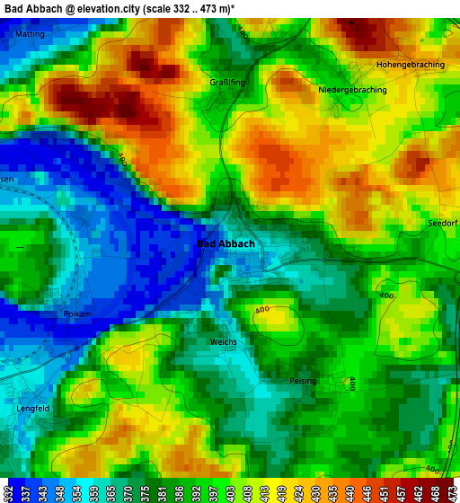
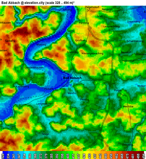
Below is the Elevation map of Bad Abbach, which displays elevation range with different colors. Scale of the first map is from 332 to 473 m (1089 to 1552 ft) with average elevation of 391.6 meters (=1285 ft) [note 1]
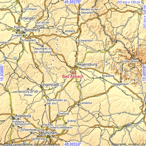
These maps also provides idea of topography and contour of this city, they are displayed at different zoom levels. More info about maps, scale and edge coordinates you can find below images.
| \ | Map #1 | Map #2 | Topo.Map |
| Scale [m] | 332..473 m | 328..494 m | × |
| Scale [ft] | 1089..1552 ft | 1076..1621 ft | × |
| Average | 391.6 m = 1285 ft | 397.6 m = 1304 ft | × |
| Width | 6.42 km = 4 mi | 12.84 km = 8 mi | 205.4 km = 127.6 mi |
| Height | 6.42 km = 4 mi | 12.84 km = 8 mi | 205.4 km = 127.6 mi |
| ↑Max Latitude | 48.966399° | 48.99524° | 49.85275° |
| Latitude at center | 48.93754° | 48.93754° | 48.93754° |
| ↓Min Latitude | 48.908665° | 48.879773° | 48.00524° |
| ← Min Longitude | 12.000995° | 11.957049° | 10.63869° |
| Longitude center | 12.04494° | 12.04494° | 12.04494° |
| →Max Longitude | 12.088885° | 12.132831° | 13.45119° |
Nearby cities:
Cities around Bad Abbach sort by population:
• Regensburg elevation 341 m
9.6 km,  25°
25°
• Nittendorf 413 m
11.4 km,  327°
327°
• Reinhausen 339 m
11.5 km, 25°
• Obertraubling 339 m
9.5 km,  69°
69°
• Sinzing 337 m
7 km,  353°
353°
• Saal 348 m
9.2 km,  243°
243°
• Pentling 410 m
5.2 km,  11°
11°
• Thalmassing 355 m
8.5 km,  109°
109°
• Alteglofsheim 372 m
11.6 km,  101°
101°
• Köfering 354 m
11.3 km,  92°
92°
• Hausen 377 m
9.1 km,  198°
198°
• Teugn 378 m
5.5 km,  206°
206°
Multilingual:
 En español:
Bad Abbach elevación 355 m.
 En France:
Bad Abbach élévation 355 m.
 Auf Deutsch:
Bad Abbach höhe über dem Meeresspiegel ist 355 m.

Sources and notes:
- [note 1] Map square and city borders are not equal. Map elevation data is calculated only from area inside that square.
- [src 1] Elevation data from geonames database provided with same terms of usage.
- [src 2] The elevation map of Bad Abbach is generated using elevation data from NASA's 3 arcsec (90m) resolution SRTM data.
- [src 3] Base (background) map © OpenStreetMap contributors tiles are generated by Geofabrik and OpenTopoMap.
Copyright & License:
This Bad Abbach Elevation Map is licensed under CC BY-SA. You may reuse any part from this page, if you give a proper credit by linking to this URL:
 More info on terms of use page.