Neubrunn elevation
Neubrunn (Bavaria, Regierungsbezirk Unterfranken), Germany elevation is 290 meters and Neubrunn elevation in feet is 951 ft above sea level [src 1]. Neubrunn is a populated place (feature code) with elevation that is 32 meters (105 ft) bigger than average city elevation in Germany.
Below is the Elevation map of Neubrunn, which displays elevation range with different colors. Scale of the first map is from 219 to 395 m (719 to 1296 ft) with average elevation of 317 meters (=1040 ft) [note 1]
These maps also provides idea of topography and contour of this city, they are displayed at different zoom levels. More info about maps, scale and edge coordinates you can find below images.
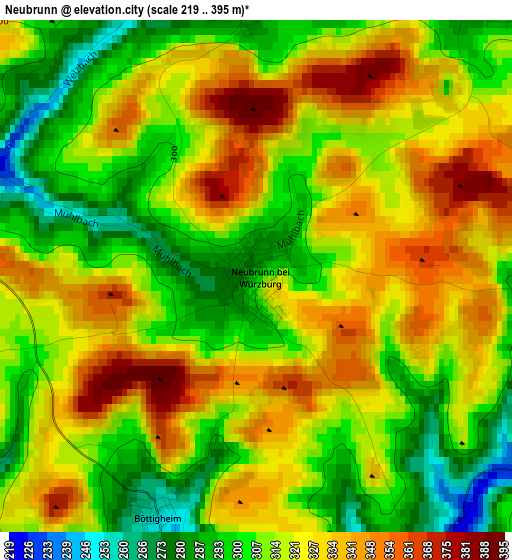
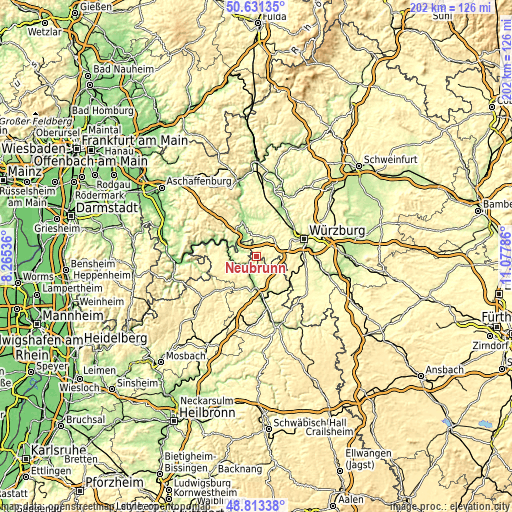
| \ | Map #1 | Topo.Map |
| Scale [m] | 219..395 m | × |
| Scale [ft] | 719..1296 ft | × |
| Average | 317 m = 1040 ft | × |
| Width | 6.32 km = 3.9 mi | 202.1 km = 125.6 mi |
| Height | 6.32 km = 3.9 mi | 202.1 km = 125.6 mi |
| ↑Max Latitude | 49.759277° | 50.63135° |
| Latitude at center | 49.73088° | 49.73088° |
| ↓Min Latitude | 49.702466° | 48.81338° |
| ← Min Longitude | 9.627665° | 8.26536° |
| Longitude center | 9.67161° | 9.67161° |
| →Max Longitude | 9.715555° | 11.07786° |
Nearby cities:
Cities around Neubrunn sort by population:
• Wertheim elevation 174 m
12.1 km,  284°
284°
• Tauberbischofsheim 176 m
11.8 km,  183°
183°
• Großrinderfeld 311 m
8.5 km,  148°
148°
• Kreuzwertheim 150 m
11.8 km,  290°
290°
• Werbach 186 m
7.1 km,  199°
199°
• Eisingen 316 m
11.9 km,  74°
74°
• Waldbrunn 316 m
10 km, 71°
• Helmstadt 302 m
4.3 km,  37°
37°
• Kist 364 m
12.5 km,  83°
83°
• Uettingen 241 m
8.3 km,  30°
30°
• Greußenheim 268 m
11.7 km, 35°
• Remlingen 259 m
8.4 km,  11°
11°
Multilingual:
 En español:
Neubrunn elevación 290 m.
 En France:
Neubrunn élévation 290 m.
 Auf Deutsch:
Neubrunn höhe über dem Meeresspiegel ist 290 m.

Sources and notes:
- [note 1] Map square and city borders are not equal. Map elevation data is calculated only from area inside that square.
- [src 1] Elevation data from geonames database provided with same terms of usage.
- [src 2] The elevation map of Neubrunn is generated using elevation data from NASA's 3 arcsec (90m) resolution SRTM data.
- [src 3] Base (background) map © OpenStreetMap contributors tiles are generated by Geofabrik and OpenTopoMap.
Copyright & License:
This Neubrunn Elevation Map is licensed under CC BY-SA. You may reuse any part from this page, if you give a proper credit by linking to this URL:
 More info on terms of use page.