Remlingen elevation
Remlingen (Bavaria, Regierungsbezirk Unterfranken), Germany elevation is 259 meters and Remlingen elevation in feet is 850 ft above sea level [src 1]. Remlingen is a populated place (feature code) with elevation that is 1 meters (3 ft) bigger than average city elevation in Germany.
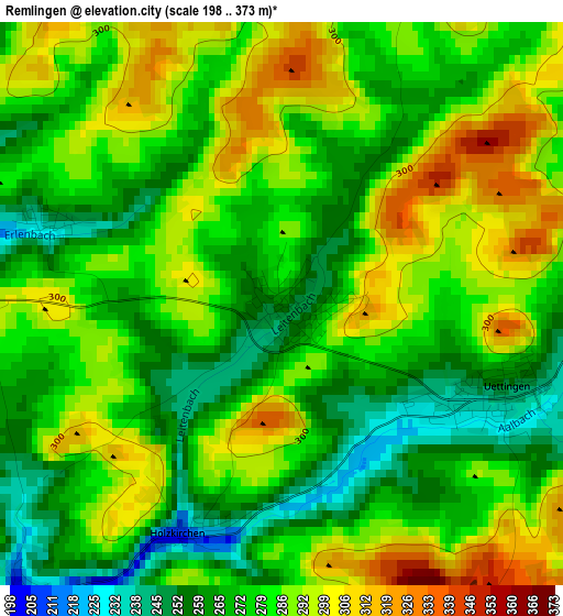
Below is the Elevation map of Remlingen, which displays elevation range with different colors. Scale of the first map is from 198 to 373 m (650 to 1224 ft) with average elevation of 280.1 meters (=919 ft) [note 1]
These maps also provides idea of topography and contour of this city, they are displayed at different zoom levels. More info about maps, scale and edge coordinates you can find below images.
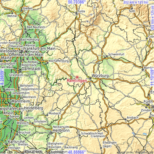
| \ | Map #1 | Topo.Map |
| Scale [m] | 198..373 m | × |
| Scale [ft] | 650..1224 ft | × |
| Average | 280.1 m = 919 ft | × |
| Width | 6.31 km = 3.9 mi | 201.8 km = 125.4 mi |
| Height | 6.31 km = 3.9 mi | 201.8 km = 125.4 mi |
| ↑Max Latitude | 49.833124° | 50.70386° |
| Latitude at center | 49.80477° | 49.80477° |
| ↓Min Latitude | 49.7764° | 48.88866° |
| ← Min Longitude | 9.650895° | 8.28859° |
| Longitude center | 9.69484° | 9.69484° |
| →Max Longitude | 9.738785° | 11.10109° |
Nearby cities:
Cities around Remlingen sort by population:
• Marktheidenfeld elevation 162 m
8 km,  304°
304°
• Waldbüttelbrunn 323 m
11 km,  99°
99°
• Hettstadt 285 m
8.6 km,  93°
93°
• Waldbrunn 316 m
9.3 km,  123°
123°
• Helmstadt 302 m
4.9 km,  168°
168°
• Neubrunn 290 m
8.4 km,  191°
191°
• Birkenfeld 210 m
6 km,  0°
0°
• Uettingen 241 m
2.8 km,  113°
113°
• Hafenlohr 154 m
9.8 km,  317°
317°
• Greußenheim 268 m
5.3 km,  75°
75°
• Karbach 189 m
8 km,  329°
329°
• Urspringen 276 m
10.9 km,  351°
351°
Multilingual:
 En español:
Remlingen elevación 259 m.
 En France:
Remlingen élévation 259 m.
 Auf Deutsch:
Remlingen höhe über dem Meeresspiegel ist 259 m.

Sources and notes:
- [note 1] Map square and city borders are not equal. Map elevation data is calculated only from area inside that square.
- [src 1] Elevation data from geonames database provided with same terms of usage.
- [src 2] The elevation map of Remlingen is generated using elevation data from NASA's 3 arcsec (90m) resolution SRTM data.
- [src 3] Base (background) map © OpenStreetMap contributors tiles are generated by Geofabrik and OpenTopoMap.
Copyright & License:
This Remlingen Elevation Map is licensed under CC BY-SA. You may reuse any part from this page, if you give a proper credit by linking to this URL:
 More info on terms of use page.