Oberrot elevation
Oberrot (Baden-Württemberg, Regierungsbezirk Stuttgart), Germany elevation is 358 meters and Oberrot elevation in feet is 1175 ft above sea level [src 1]. Oberrot is a seat of a fourth-order administrative division (feature code) with elevation that is 100 meters (328 ft) bigger than average city elevation in Germany.
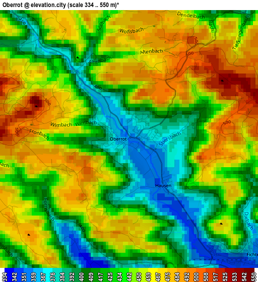
Below is the Elevation map of Oberrot, which displays elevation range with different colors. Scale of the first map is from 334 to 550 m (1096 to 1804 ft) with average elevation of 439.4 meters (=1442 ft) [note 1]
These maps also provides idea of topography and contour of this city, they are displayed at different zoom levels. More info about maps, scale and edge coordinates you can find below images.
| \ | Map #1 | Map #2 | Topo.Map |
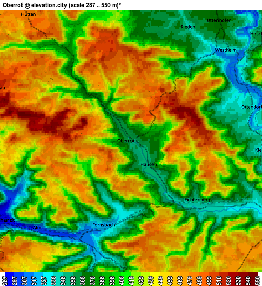
| Scale [m] | 334..550 m | 287..550 m | × |
| Scale [ft] | 1096..1804 ft | 942..1804 ft | × |
| Average | 439.4 m = 1442 ft | 425 m = 1394 ft | × |
| Width | 6.41 km = 4 mi | 12.82 km = 8 mi | 205.1 km = 127.4 mi |
| Height | 6.41 km = 4 mi | 12.82 km = 8 mi | 205.1 km = 127.4 mi |
| ↑Max Latitude | 49.043254° | 49.072051° | 49.92823° |
| Latitude at center | 49.01444° | 49.01444° | 49.01444° |
| ↓Min Latitude | 48.985609° | 48.956762° | 48.08357° |
| ← Min Longitude | 9.623275° | 9.579329° | 8.26097° |
| Longitude center | 9.66722° | 9.66722° | 9.66722° |
| →Max Longitude | 9.711165° | 9.755111° | 11.07347° |
Nearby cities:
Cities around Oberrot sort by population:
• Schwäbisch Hall elevation 322 m
12 km,  25°
25°
• Murrhardt 286 m
7.9 km,  242°
242°
• Gaildorf 337 m
7.6 km,  101°
101°
• Mainhardt 492 m
10.6 km,  310°
310°
• Sulzbach an der Murr 278 m
12.2 km,  264°
264°
• Gschwend 473 m
10.6 km,  148°
148°
• Althütte 497 m
13.1 km,  212°
212°
• Michelfeld 362 m
9.3 km,  5°
5°
• Michelbach an der Bilz 364 m
9.3 km,  48°
48°
• Fichtenberg 345 m
4.5 km,  134°
134°
• Kaisersbach 569 m
9.6 km,  192°
192°
• Großerlach 522 m
12 km,  291°
291°
Multilingual:
 En español:
Oberrot elevación 358 m.
 En France:
Oberrot élévation 358 m.


Sources and notes:
- [note 1] Map square and city borders are not equal. Map elevation data is calculated only from area inside that square.
- [src 1] Elevation data from geonames database provided with same terms of usage.
- [src 2] The elevation map of Oberrot is generated using elevation data from NASA's 3 arcsec (90m) resolution SRTM data.
- [src 3] Base (background) map © OpenStreetMap contributors tiles are generated by Geofabrik and OpenTopoMap.
Copyright & License:
This Oberrot Elevation Map is licensed under CC BY-SA. You may reuse any part from this page, if you give a proper credit by linking to this URL:
 More info on terms of use page.