Obersinn elevation
Obersinn (Bavaria, Regierungsbezirk Unterfranken), Germany elevation is 208 meters and Obersinn elevation in feet is 682 ft above sea level [src 1]. Obersinn is a populated place (feature code) with elevation that is 50 meters (164 ft) smaller than average city elevation in Germany.
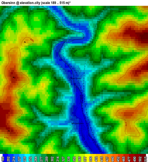
Below is the Elevation map of Obersinn, which displays elevation range with different colors. Scale of the first map is from 189 to 515 m (620 to 1690 ft) with average elevation of 327.6 meters (=1075 ft) [note 1]
These maps also provides idea of topography and contour of this city, they are displayed at different zoom levels. More info about maps, scale and edge coordinates you can find below images.
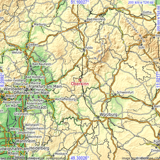
| \ | Map #1 | Topo.Map |
| Scale [m] | 189..515 m | × |
| Scale [ft] | 620..1690 ft | × |
| Average | 327.6 m = 1075 ft | × |
| Width | 6.25 km = 3.9 mi | 200.1 km = 124.3 mi |
| Height | 6.25 km = 3.9 mi | 200.1 km = 124.3 mi |
| ↑Max Latitude | 50.236866° | 51.10027° |
| Latitude at center | 50.20875° | 50.20875° |
| ↓Min Latitude | 50.180617° | 49.30026° |
| ← Min Longitude | 9.571505° | 8.2092° |
| Longitude center | 9.61545° | 9.61545° |
| →Max Longitude | 9.659395° | 11.0217° |
Nearby cities:
Cities around Obersinn sort by population:
• Schlüchtern elevation 211 m
16.8 km,  337°
337°
• Steinau an der Straße 175 m
15.9 km,  317°
317°
• Bad Brückenau 315 m
16.6 km,  48°
48°
• Burgsinn 194 m
7 km,  158°
158°
• Wartmannsroth 331 m
12.8 km,  111°
111°
• Zeitlofs 248 m
7.2 km,  34°
34°
• Rieneck 188 m
13 km,  169°
169°
• Oberleichtersbach 469 m
15.5 km,  57°
57°
• Schondra 419 m
18.8 km,  69°
69°
• Gräfendorf 165 m
13.1 km,  137°
137°
• Schönau 168 m
16.6 km,  152°
152°
• Aura im Sinngrund 283 m
4.4 km,  219°
219°
Multilingual:
 En español:
Obersinn elevación 208 m.
 En France:
Obersinn élévation 208 m.
 Auf Deutsch:
Obersinn höhe über dem Meeresspiegel ist 208 m.

Sources and notes:
- [note 1] Map square and city borders are not equal. Map elevation data is calculated only from area inside that square.
- [src 1] Elevation data from geonames database provided with same terms of usage.
- [src 2] The elevation map of Obersinn is generated using elevation data from NASA's 3 arcsec (90m) resolution SRTM data.
- [src 3] Base (background) map © OpenStreetMap contributors tiles are generated by Geofabrik and OpenTopoMap.
Copyright & License:
This Obersinn Elevation Map is licensed under CC BY-SA. You may reuse any part from this page, if you give a proper credit by linking to this URL:
 More info on terms of use page.