Schondra elevation
Schondra (Bavaria, Regierungsbezirk Unterfranken), Germany elevation is 419 meters and Schondra elevation in feet is 1375 ft above sea level [src 1]. Schondra is a populated place (feature code) with elevation that is 161 meters (528 ft) bigger than average city elevation in Germany.
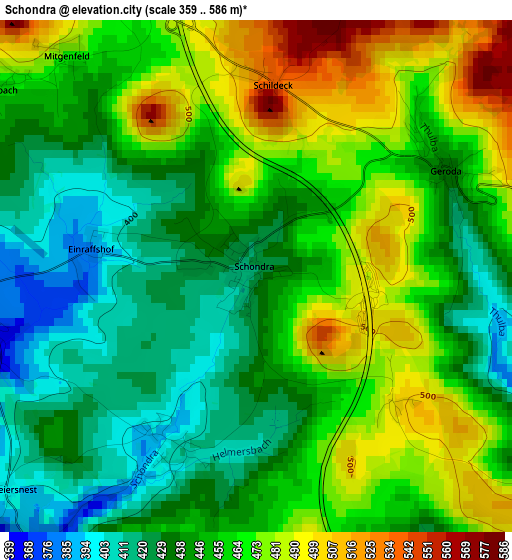
Below is the Elevation map of Schondra, which displays elevation range with different colors. Scale of the first map is from 359 to 586 m (1178 to 1923 ft) with average elevation of 453.7 meters (=1489 ft) [note 1]
These maps also provides idea of topography and contour of this city, they are displayed at different zoom levels. More info about maps, scale and edge coordinates you can find below images.
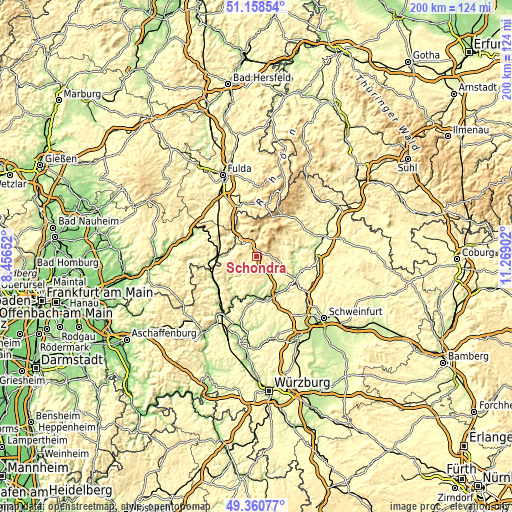
| \ | Map #1 | Topo.Map |
| Scale [m] | 359..586 m | × |
| Scale [ft] | 1178..1923 ft | × |
| Average | 453.7 m = 1489 ft | × |
| Width | 6.25 km = 3.9 mi | 199.9 km = 124.2 mi |
| Height | 6.25 km = 3.9 mi | 199.9 km = 124.2 mi |
| ↑Max Latitude | 50.296221° | 51.15854° |
| Latitude at center | 50.26814° | 50.26814° |
| ↓Min Latitude | 50.240042° | 49.36077° |
| ← Min Longitude | 9.818825° | 8.45652° |
| Longitude center | 9.86277° | 9.86277° |
| →Max Longitude | 9.906715° | 11.26902° |
Nearby cities:
Cities around Schondra sort by population:
• Burkardroth elevation 316 m
9.2 km,  87°
87°
• Bad Brückenau 315 m
6.9 km,  310°
310°
• Oberthulba 271 m
10.3 km,  138°
138°
• Bad Bocklet 226 m
15.4 km, 90°
• Wildflecken 516 m
12.6 km,  15°
15°
• Elfershausen 198 m
15.1 km,  152°
152°
• Sandberg 491 m
13.6 km,  49°
49°
• Wartmannsroth 331 m
12.6 km,  206°
206°
• Zeitlofs 248 m
13.5 km,  267°
267°
• Oberleichtersbach 469 m
4.8 km,  290°
290°
• Motten 413 m
15.6 km,  335°
335°
• Riedenberg 393 m
5.8 km,  358°
358°
Multilingual:
 En español:
Schondra elevación 419 m.
 En France:
Schondra élévation 419 m.
 Auf Deutsch:
Schondra höhe über dem Meeresspiegel ist 419 m.

Sources and notes:
- [note 1] Map square and city borders are not equal. Map elevation data is calculated only from area inside that square.
- [src 1] Elevation data from geonames database provided with same terms of usage.
- [src 2] The elevation map of Schondra is generated using elevation data from NASA's 3 arcsec (90m) resolution SRTM data.
- [src 3] Base (background) map © OpenStreetMap contributors tiles are generated by Geofabrik and OpenTopoMap.
Copyright & License:
This Schondra Elevation Map is licensed under CC BY-SA. You may reuse any part from this page, if you give a proper credit by linking to this URL:
 More info on terms of use page.