Sandberg elevation
Sandberg (Bavaria, Regierungsbezirk Unterfranken), Germany elevation is 491 meters and Sandberg elevation in feet is 1611 ft above sea level [src 1]. Sandberg is a seat of a fourth-order administrative division (feature code) with elevation that is 233 meters (764 ft) bigger than average city elevation in Germany.
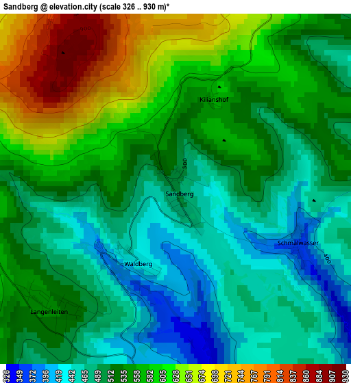
Below is the Elevation map of Sandberg, which displays elevation range with different colors. Scale of the first map is from 326 to 930 m (1070 to 3051 ft) with average elevation of 535.7 meters (=1758 ft) [note 1]
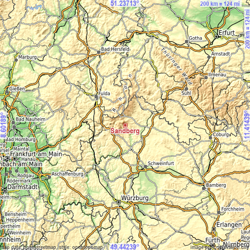
These maps also provides idea of topography and contour of this city, they are displayed at different zoom levels. More info about maps, scale and edge coordinates you can find below images.
| \ | Map #1 | Topo.Map |
| Scale [m] | 326..930 m | × |
| Scale [ft] | 1070..3051 ft | × |
| Average | 535.7 m = 1758 ft | × |
| Width | 6.24 km = 3.9 mi | 199.6 km = 124 mi |
| Height | 6.24 km = 3.9 mi | 199.5 km = 124 mi |
| ↑Max Latitude | 50.376274° | 51.23713° |
| Latitude at center | 50.34824° | 50.34824° |
| ↓Min Latitude | 50.320189° | 49.44239° |
| ← Min Longitude | 9.964195° | 8.60189° |
| Longitude center | 10.00814° | 10.00814° |
| →Max Longitude | 10.052085° | 11.41439° |
Nearby cities:
Cities around Sandberg sort by population:
• Bad Neustadt an der Saale elevation 235 m
14.4 km,  101°
101°
• Burkardroth 316 m
8.6 km,  187°
187°
• Gersfeld 486 m
13.3 km,  329°
329°
• Bischofsheim an der Rhön 451 m
6 km,  359°
359°
• Bad Bocklet 226 m
10.4 km,  151°
151°
• Wildflecken 516 m
7.6 km,  295°
295°
• Oberelsbach 406 m
12.9 km,  36°
36°
• Bastheim 291 m
15.1 km,  67°
67°
• Schondra 419 m
13.6 km,  229°
229°
• Niederlauer 239 m
13.4 km,  116°
116°
• Burglauer 236 m
14.5 km, 123°
• Riedenberg 393 m
10.9 km,  253°
253°
Multilingual:
 En español:
Sandberg elevación 491 m.
 En France:
Sandberg élévation 491 m.
 Auf Deutsch:
Sandberg höhe über dem Meeresspiegel ist 491 m.

Sources and notes:
- [note 1] Map square and city borders are not equal. Map elevation data is calculated only from area inside that square.
- [src 1] Elevation data from geonames database provided with same terms of usage.
- [src 2] The elevation map of Sandberg is generated using elevation data from NASA's 3 arcsec (90m) resolution SRTM data.
- [src 3] Base (background) map © OpenStreetMap contributors tiles are generated by Geofabrik and OpenTopoMap.
Copyright & License:
This Sandberg Elevation Map is licensed under CC BY-SA. You may reuse any part from this page, if you give a proper credit by linking to this URL:
 More info on terms of use page.