Oberelsbach elevation
Oberelsbach (Bavaria, Regierungsbezirk Unterfranken), Germany elevation is 406 meters and Oberelsbach elevation in feet is 1332 ft above sea level [src 1]. Oberelsbach is a populated place (feature code) with elevation that is 148 meters (486 ft) bigger than average city elevation in Germany.
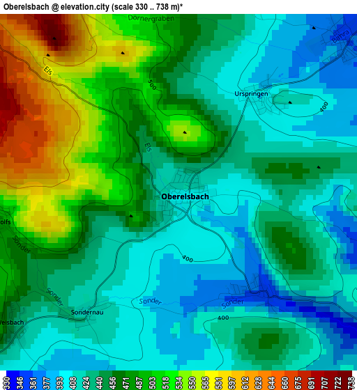
Below is the Elevation map of Oberelsbach, which displays elevation range with different colors. Scale of the first map is from 330 to 738 m (1083 to 2421 ft) with average elevation of 454.9 meters (=1492 ft) [note 1]
These maps also provides idea of topography and contour of this city, they are displayed at different zoom levels. More info about maps, scale and edge coordinates you can find below images.
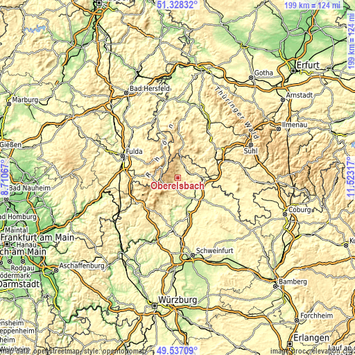
| \ | Map #1 | Topo.Map |
| Scale [m] | 330..738 m | × |
| Scale [ft] | 1083..2421 ft | × |
| Average | 454.9 m = 1492 ft | × |
| Width | 6.22 km = 3.9 mi | 199.2 km = 123.8 mi |
| Height | 6.22 km = 3.9 mi | 199.2 km = 123.8 mi |
| ↑Max Latitude | 50.469159° | 51.32832° |
| Latitude at center | 50.44118° | 50.44118° |
| ↓Min Latitude | 50.413184° | 49.53709° |
| ← Min Longitude | 10.072975° | 8.71067° |
| Longitude center | 10.11692° | 10.11692° |
| →Max Longitude | 10.160865° | 11.52317° |
Nearby cities:
Cities around Oberelsbach sort by population:
• Mellrichstadt elevation 280 m
13.3 km,  96°
96°
• Bischofsheim an der Rhön 451 m
8.9 km,  240°
240°
• Ostheim vor der Rhön 313 m
8.3 km,  75°
75°
• Sandberg 491 m
12.9 km,  216°
216°
• Bastheim 291 m
7.6 km,  126°
126°
• Fladungen 414 m
9.1 km,  13°
13°
• Oberstreu 258 m
12.8 km,  109°
109°
• Heustreu 251 m
14 km, 133°
• Frankenheim 757 m
12 km,  343°
343°
• Wollbach 262 m
11.7 km,  135°
135°
• Stockheim 299 m
11.2 km, 79°
• Sondheim vor der Rhön 358 m
3.9 km,  46°
46°
Multilingual:
 En español:
Oberelsbach elevación 406 m.
 En France:
Oberelsbach élévation 406 m.
 Auf Deutsch:
Oberelsbach höhe über dem Meeresspiegel ist 406 m.

Sources and notes:
- [note 1] Map square and city borders are not equal. Map elevation data is calculated only from area inside that square.
- [src 1] Elevation data from geonames database provided with same terms of usage.
- [src 2] The elevation map of Oberelsbach is generated using elevation data from NASA's 3 arcsec (90m) resolution SRTM data.
- [src 3] Base (background) map © OpenStreetMap contributors tiles are generated by Geofabrik and OpenTopoMap.
Copyright & License:
This Oberelsbach Elevation Map is licensed under CC BY-SA. You may reuse any part from this page, if you give a proper credit by linking to this URL:
 More info on terms of use page.