Bad Neustadt an der Saale elevation
Bad Neustadt an der Saale (Bavaria, Regierungsbezirk Unterfranken), Germany elevation is 235 meters and Bad Neustadt an der Saale elevation in feet is 771 ft above sea level [src 1]. Bad Neustadt an der Saale is a populated place (feature code) with elevation that is 23 meters (75 ft) smaller than average city elevation in Germany.
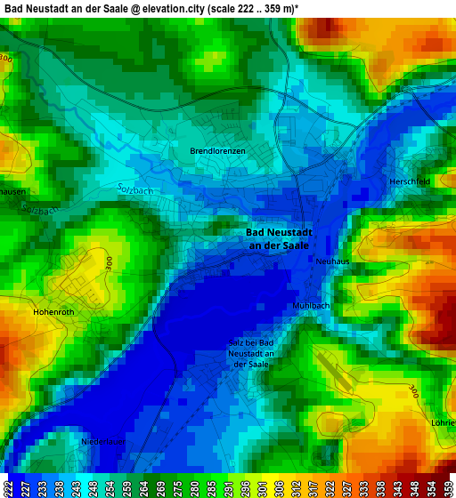
Below is the Elevation map of Bad Neustadt an der Saale, which displays elevation range with different colors. Scale of the first map is from 222 to 359 m (728 to 1178 ft) with average elevation of 265.6 meters (=871 ft) [note 1]
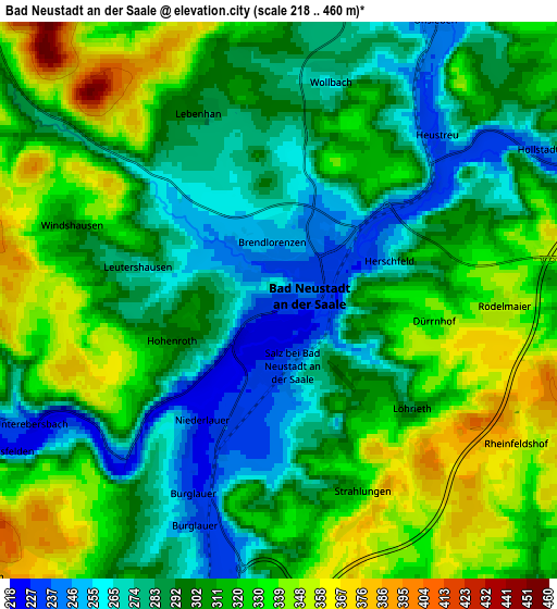
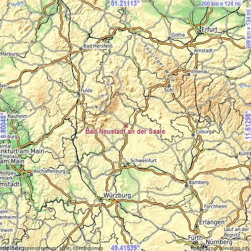
These maps also provides idea of topography and contour of this city, they are displayed at different zoom levels. More info about maps, scale and edge coordinates you can find below images.
| \ | Map #1 | Map #2 | Topo.Map |
| Scale [m] | 222..359 m | 218..460 m | × |
| Scale [ft] | 728..1178 ft | 715..1509 ft | × |
| Average | 265.6 m = 871 ft | 305.8 m = 1003 ft | × |
| Width | 6.24 km = 3.9 mi | 12.48 km = 7.8 mi | 199.7 km = 124.1 mi |
| Height | 6.24 km = 3.9 mi | 12.48 km = 7.8 mi | 199.7 km = 124.1 mi |
| ↑Max Latitude | 50.34979° | 50.377823° | 51.21113° |
| Latitude at center | 50.32174° | 50.32174° | 50.32174° |
| ↓Min Latitude | 50.293674° | 50.265591° | 49.41539° |
| ← Min Longitude | 10.162785° | 10.118839° | 8.80048° |
| Longitude center | 10.20673° | 10.20673° | 10.20673° |
| →Max Longitude | 10.250675° | 10.294621° | 11.61298° |
Nearby cities:
Cities around Bad Neustadt an der Saale sort by population:
• Münnerstadt elevation 248 m
8.4 km,  182°
182°
• Bad Bocklet 226 m
11 km,  235°
235°
• Bastheim 291 m
8.8 km,  358°
358°
• Salz 241 m
1.5 km,  165°
165°
• Niederlauer 239 m
3.7 km,  214°
214°
• Oberstreu 258 m
10.7 km,  32°
32°
• Hollstadt 243 m
7.3 km,  64°
64°
• Burglauer 236 m
5.4 km,  201°
201°
• Saal an der Saale 257 m
10.7 km,  92°
92°
• Wülfershausen 251 m
9.6 km,  83°
83°
• Heustreu 251 m
5.3 km,  46°
46°
• Wollbach 262 m
5.3 km,  20°
20°
Multilingual:
 En español:
Bad Neustadt an der Saale elevación 235 m.
 En France:
Bad Neustadt an der Saale élévation 235 m.
 Auf Deutsch:
Bad Neustadt an der Saale höhe über dem Meeresspiegel ist 235 m.
 На русском:
Бад-Нойштадт-ан-дер-Зале высота над уровнем моря 235 м
Sources and notes:
- [note 1] Map square and city borders are not equal. Map elevation data is calculated only from area inside that square.
- [src 1] Elevation data from geonames database provided with same terms of usage.
- [src 2] The elevation map of Bad Neustadt an der Saale is generated using elevation data from NASA's 3 arcsec (90m) resolution SRTM data.
- [src 3] Base (background) map © OpenStreetMap contributors tiles are generated by Geofabrik and OpenTopoMap.
Copyright & License:
This Bad Neustadt an der Saale Elevation Map is licensed under CC BY-SA. You may reuse any part from this page, if you give a proper credit by linking to this URL:
 More info on terms of use page.