Schönau elevation
Schönau (Bavaria, Regierungsbezirk Unterfranken), Germany elevation is 168 meters and Schönau elevation in feet is 551 ft above sea level [src 1]. Schönau is a populated place (feature code) with elevation that is 90 meters (295 ft) smaller than average city elevation in Germany.
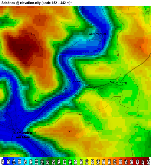
Below is the Elevation map of Schönau, which displays elevation range with different colors. Scale of the first map is from 152 to 442 m (499 to 1450 ft) with average elevation of 287.5 meters (=943 ft) [note 1]
These maps also provides idea of topography and contour of this city, they are displayed at different zoom levels. More info about maps, scale and edge coordinates you can find below images.
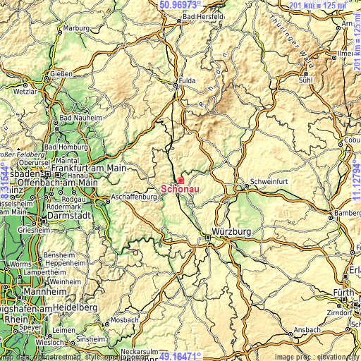
| \ | Map #1 | Topo.Map |
| Scale [m] | 152..442 m | × |
| Scale [ft] | 499..1450 ft | × |
| Average | 287.5 m = 943 ft | × |
| Width | 6.27 km = 3.9 mi | 200.7 km = 124.7 mi |
| Height | 6.27 km = 3.9 mi | 200.7 km = 124.7 mi |
| ↑Max Latitude | 50.103905° | 50.96973° |
| Latitude at center | 50.07571° | 50.07571° |
| ↓Min Latitude | 50.047499° | 49.16471° |
| ← Min Longitude | 9.677745° | 8.31544° |
| Longitude center | 9.72169° | 9.72169° |
| →Max Longitude | 9.765635° | 11.12794° |
Nearby cities:
Cities around Schönau sort by population:
• Karlstadt elevation 172 m
13.3 km,  164°
164°
• Hammelburg 193 m
12.9 km,  69°
69°
• Gemünden am Main 179 m
3.1 km,  201°
201°
• Eußenheim 183 m
11.8 km,  148°
148°
• Burgsinn 194 m
9.6 km,  328°
328°
• Erlenbach 283 m
12.1 km,  207°
207°
• Wartmannsroth 331 m
11 km,  23°
23°
• Steinfeld 279 m
14.2 km, 195°
• Rieneck 188 m
5.6 km,  290°
290°
• Karsbach 215 m
6 km,  130°
130°
• Gräfendorf 165 m
5.4 km,  14°
14°
• Gössenheim 172 m
7.9 km, 146°
Multilingual:
 En español:
Schönau elevación 168 m.
 En France:
Schönau élévation 168 m.


Sources and notes:
- [note 1] Map square and city borders are not equal. Map elevation data is calculated only from area inside that square.
- [src 1] Elevation data from geonames database provided with same terms of usage.
- [src 2] The elevation map of Schönau is generated using elevation data from NASA's 3 arcsec (90m) resolution SRTM data.
- [src 3] Base (background) map © OpenStreetMap contributors tiles are generated by Geofabrik and OpenTopoMap.
Copyright & License:
This Schönau Elevation Map is licensed under CC BY-SA. You may reuse any part from this page, if you give a proper credit by linking to this URL:
 More info on terms of use page.