Ottenstein elevation
Ottenstein (Lower Saxony), Germany elevation is 290 meters and Ottenstein elevation in feet is 951 ft above sea level [src 1]. Ottenstein is a populated place (feature code) with elevation that is 32 meters (105 ft) bigger than average city elevation in Germany.
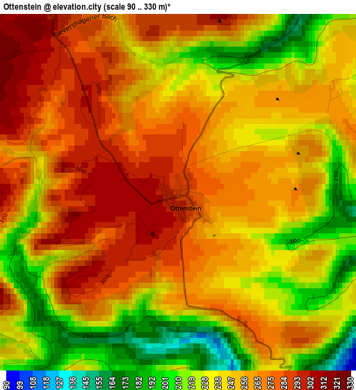
Below is the Elevation map of Ottenstein, which displays elevation range with different colors. Scale of the first map is from 90 to 330 m (295 to 1083 ft) with average elevation of 250.9 meters (=823 ft) [note 1]
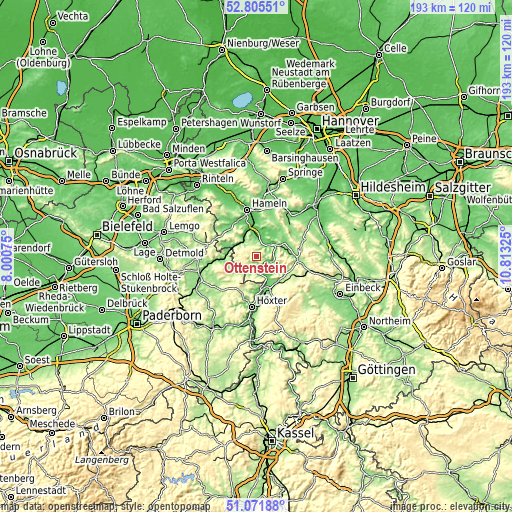
These maps also provides idea of topography and contour of this city, they are displayed at different zoom levels. More info about maps, scale and edge coordinates you can find below images.
| \ | Map #1 | Topo.Map |
| Scale [m] | 90..330 m | × |
| Scale [ft] | 295..1083 ft | × |
| Average | 250.9 m = 823 ft | × |
| Width | 6.02 km = 3.7 mi | 192.8 km = 119.8 mi |
| Height | 6.02 km = 3.7 mi | 192.7 km = 119.7 mi |
| ↑Max Latitude | 51.974149° | 52.80551° |
| Latitude at center | 51.94707° | 51.94707° |
| ↓Min Latitude | 51.919974° | 51.07188° |
| ← Min Longitude | 9.363055° | 8.00075° |
| Longitude center | 9.407° | 9.407° |
| →Max Longitude | 9.450945° | 10.81325° |
Nearby cities:
Cities around Ottenstein sort by population:
• Bad Pyrmont elevation 113 m
11.4 km,  292°
292°
• Holzminden 91 m
13.5 km,  168°
168°
• Lügde 106 m
11 km,  276°
276°
• Aerzen 105 m
15.3 km,  318°
318°
• Bodenwerder 95 m
8.2 km,  70°
70°
• Bevern 100 m
11.5 km,  148°
148°
• Hehlen 73 m
6.3 km,  43°
43°
• Halle 96 m
11.9 km, 65°
• Deensen 261 m
16 km,  126°
126°
• Polle 92 m
5.4 km,  182°
182°
• Kirchbrak 116 m
11.7 km,  79°
79°
• Golmbach 138 m
11.1 km,  118°
118°
Multilingual:
 En español:
Ottenstein elevación 290 m.
 En France:
Ottenstein élévation 290 m.
 Auf Deutsch:
Ottenstein höhe über dem Meeresspiegel ist 290 m.

Sources and notes:
- [note 1] Map square and city borders are not equal. Map elevation data is calculated only from area inside that square.
- [src 1] Elevation data from geonames database provided with same terms of usage.
- [src 2] The elevation map of Ottenstein is generated using elevation data from NASA's 3 arcsec (90m) resolution SRTM data.
- [src 3] Base (background) map © OpenStreetMap contributors tiles are generated by Geofabrik and OpenTopoMap.
Copyright & License:
This Ottenstein Elevation Map is licensed under CC BY-SA. You may reuse any part from this page, if you give a proper credit by linking to this URL:
 More info on terms of use page.