Stadtroda elevation
Stadtroda (Thuringia), Germany elevation is 199 meters and Stadtroda elevation in feet is 653 ft above sea level [src 1]. Stadtroda is a populated place (feature code) with elevation that is 59 meters (194 ft) smaller than average city elevation in Germany.
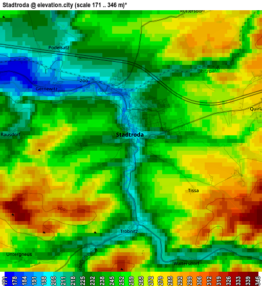
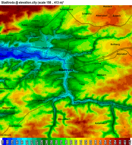
Below is the Elevation map of Stadtroda, which displays elevation range with different colors. Scale of the first map is from 171 to 346 m (561 to 1135 ft) with average elevation of 252.5 meters (=828 ft) [note 1]
These maps also provides idea of topography and contour of this city, they are displayed at different zoom levels. More info about maps, scale and edge coordinates you can find below images.
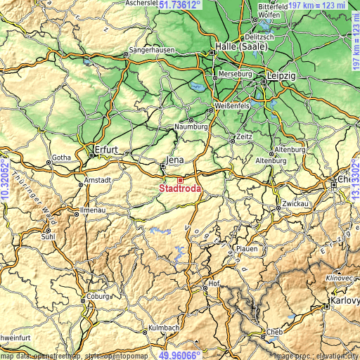
| \ | Map #1 | Map #2 | Topo.Map |
| Scale [m] | 171..346 m | 158..413 m | × |
| Scale [ft] | 561..1135 ft | 518..1355 ft | × |
| Average | 252.5 m = 828 ft | 290 m = 951 ft | × |
| Width | 6.17 km = 3.8 mi | 12.34 km = 7.7 mi | 197.4 km = 122.7 mi |
| Height | 6.17 km = 3.8 mi | 12.34 km = 7.7 mi | 197.4 km = 122.7 mi |
| ↑Max Latitude | 50.884573° | 50.912289° | 51.73612° |
| Latitude at center | 50.85684° | 50.85684° | 50.85684° |
| ↓Min Latitude | 50.829091° | 50.801325° | 49.96066° |
| ← Min Longitude | 11.682825° | 11.638879° | 10.32052° |
| Longitude center | 11.72677° | 11.72677° | 11.72677° |
| →Max Longitude | 11.770715° | 11.814661° | 13.13302° |
Nearby cities:
Cities around Stadtroda sort by population:
• Jena elevation 149 m
12.5 km,  309°
309°
• Hermsdorf 331 m
10.1 km,  63°
63°
• Kahla 181 m
11.4 km,  240°
240°
• Neustadt an der Orla 301 m
13.5 km,  174°
174°
• Kraftsdorf 257 m
14.4 km,  81°
81°
• Bad Klosterlausnitz 322 m
11.9 km, 55°
• Münchenbernsdorf 330 m
15 km,  105°
105°
• Bürgel 255 m
9.7 km,  12°
12°
• Rothenstein 180 m
8.9 km,  265°
265°
• Sankt Gangloff 330 m
11.8 km,  90°
90°
• Weißenborn 298 m
13.1 km, 55°
• Bucha 361 m
15 km,  281°
281°
Multilingual:
 En español:
Stadtroda elevación 199 m.
 En France:
Stadtroda élévation 199 m.
 Auf Deutsch:
Stadtroda höhe über dem Meeresspiegel ist 199 m.

Sources and notes:
- [note 1] Map square and city borders are not equal. Map elevation data is calculated only from area inside that square.
- [src 1] Elevation data from geonames database provided with same terms of usage.
- [src 2] The elevation map of Stadtroda is generated using elevation data from NASA's 3 arcsec (90m) resolution SRTM data.
- [src 3] Base (background) map © OpenStreetMap contributors tiles are generated by Geofabrik and OpenTopoMap.
Copyright & License:
This Stadtroda Elevation Map is licensed under CC BY-SA. You may reuse any part from this page, if you give a proper credit by linking to this URL:
 More info on terms of use page.