Jena elevation
Jena (Thuringia), Germany elevation is 149 meters and Jena elevation in feet is 489 ft above sea level [src 1]. Jena is a seat of a third-order administrative division (feature code) with elevation that is 109 meters (358 ft) smaller than average city elevation in Germany.
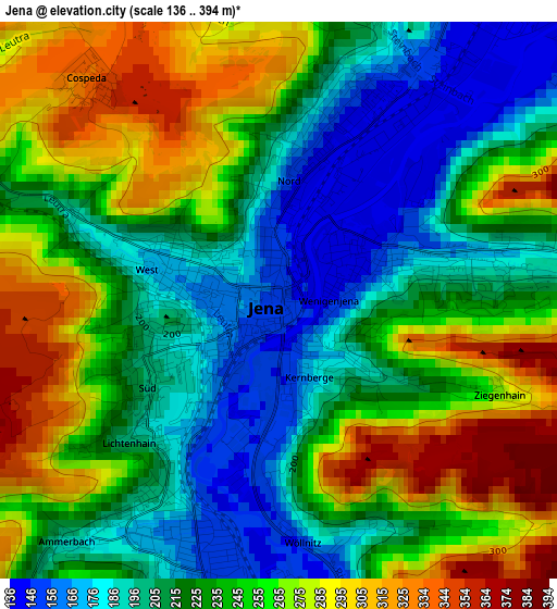
Below is the Elevation map of Jena, which displays elevation range with different colors. Scale of the first map is from 136 to 394 m (446 to 1293 ft) with average elevation of 237.3 meters (=779 ft) [note 1]
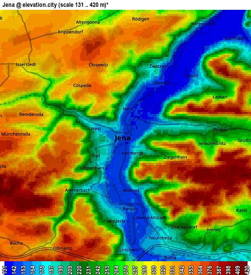
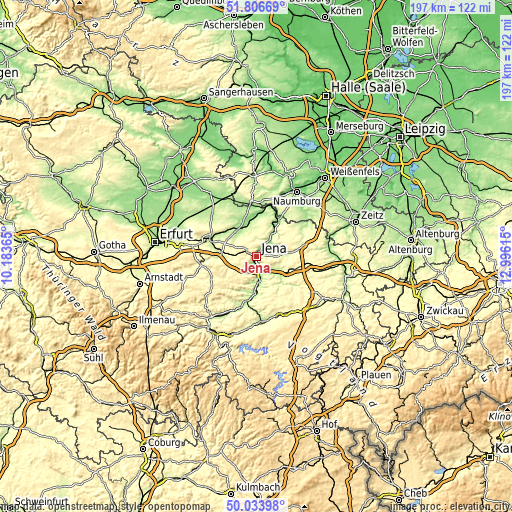
These maps also provides idea of topography and contour of this city, they are displayed at different zoom levels. More info about maps, scale and edge coordinates you can find below images.
| \ | Map #1 | Map #2 | Topo.Map |
| Scale [m] | 136..394 m | 131..420 m | × |
| Scale [ft] | 446..1293 ft | 430..1378 ft | × |
| Average | 237.3 m = 779 ft | 281.8 m = 925 ft | × |
| Width | 6.16 km = 3.8 mi | 12.32 km = 7.7 mi | 197.1 km = 122.5 mi |
| Height | 6.16 km = 3.8 mi | 12.32 km = 7.7 mi | 197.1 km = 122.5 mi |
| ↑Max Latitude | 50.95647° | 50.984143° | 51.80669° |
| Latitude at center | 50.92878° | 50.92878° | 50.92878° |
| ↓Min Latitude | 50.901074° | 50.873351° | 50.03398° |
| ← Min Longitude | 11.545955° | 11.502009° | 10.18365° |
| Longitude center | 11.5899° | 11.5899° | 11.5899° |
| →Max Longitude | 11.633845° | 11.677791° | 12.99615° |
Nearby cities:
Cities around Jena sort by population:
• Apolda elevation 171 m
12 km,  334°
334°
• Kahla 181 m
13.6 km,  181°
181°
• Stadtroda 199 m
12.5 km,  129°
129°
• Bürgel 255 m
11.8 km,  82°
82°
• Lehesten 258 m
6.1 km,  355°
355°
• Magdala 275 m
10.2 km,  256°
256°
• Rothenstein 180 m
8.8 km, 175°
• Oßmanstedt 199 m
15.1 km,  311°
311°
• Niederroßla 181 m
13.8 km, 327°
• Mellingen 228 m
13.6 km,  275°
275°
• Bucha 361 m
7.2 km,  225°
225°
• Frauenprießnitz 318 m
14 km,  45°
45°
Multilingual:
 En español:
Jena elevación 149 m.
 En France:
Iéna élévation 149 m.


Sources and notes:
- [note 1] Map square and city borders are not equal. Map elevation data is calculated only from area inside that square.
- [src 1] Elevation data from geonames database provided with same terms of usage.
- [src 2] The elevation map of Jena is generated using elevation data from NASA's 3 arcsec (90m) resolution SRTM data.
- [src 3] Base (background) map © OpenStreetMap contributors tiles are generated by Geofabrik and OpenTopoMap.
Copyright & License:
This Jena Elevation Map is licensed under CC BY-SA. You may reuse any part from this page, if you give a proper credit by linking to this URL:
 More info on terms of use page.