Kahla elevation
Kahla (Thuringia), Germany elevation is 181 meters and Kahla elevation in feet is 594 ft above sea level [src 1]. Kahla is a populated place (feature code) with elevation that is 77 meters (253 ft) smaller than average city elevation in Germany.
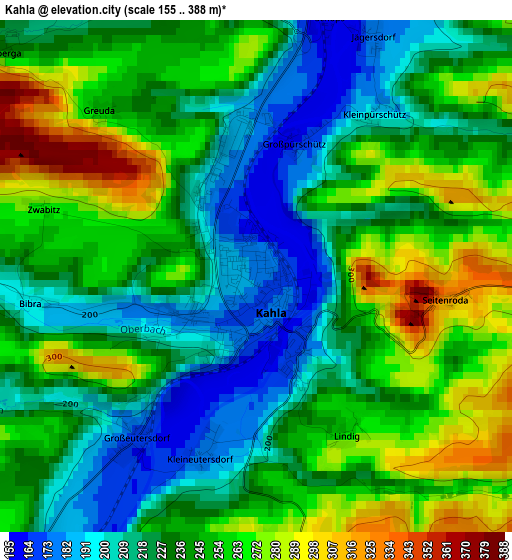
Below is the Elevation map of Kahla, which displays elevation range with different colors. Scale of the first map is from 155 to 388 m (509 to 1273 ft) with average elevation of 239.1 meters (=784 ft) [note 1]
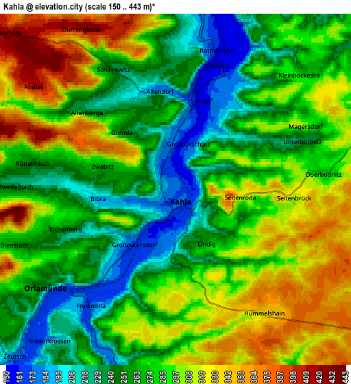
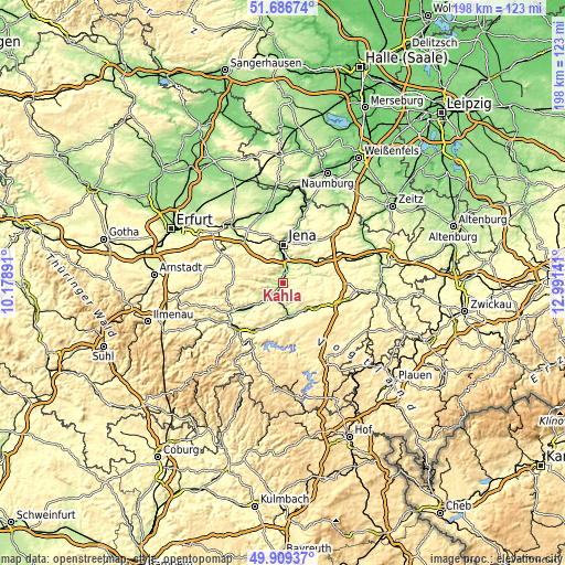
These maps also provides idea of topography and contour of this city, they are displayed at different zoom levels. More info about maps, scale and edge coordinates you can find below images.
| \ | Map #1 | Map #2 | Topo.Map |
| Scale [m] | 155..388 m | 150..443 m | × |
| Scale [ft] | 509..1273 ft | 492..1453 ft | × |
| Average | 239.1 m = 784 ft | 280.6 m = 921 ft | × |
| Width | 6.18 km = 3.8 mi | 12.35 km = 7.7 mi | 197.6 km = 122.8 mi |
| Height | 6.18 km = 3.8 mi | 12.35 km = 7.7 mi | 197.6 km = 122.8 mi |
| ↑Max Latitude | 50.834273° | 50.862019° | 51.68674° |
| Latitude at center | 50.80651° | 50.80651° | 50.80651° |
| ↓Min Latitude | 50.778731° | 50.750935° | 49.90937° |
| ← Min Longitude | 11.541215° | 11.497269° | 10.17891° |
| Longitude center | 11.58516° | 11.58516° | 11.58516° |
| →Max Longitude | 11.629105° | 11.673051° | 12.99141° |
Nearby cities:
Cities around Kahla sort by population:
• Jena elevation 149 m
13.6 km,  1°
1°
• Pößneck 228 m
12.6 km,  177°
177°
• Neustadt an der Orla 301 m
13.7 km,  124°
124°
• Stadtroda 199 m
11.4 km,  60°
60°
• Krölpa 248 m
14.7 km,  192°
192°
• Magdala 275 m
14.7 km,  319°
319°
• Langenorla 186 m
7.3 km, 182°
• Rothenstein 180 m
4.9 km,  12°
12°
• Oppurg 218 m
11.7 km,  155°
155°
• Orlamünde 251 m
5.8 km,  232°
232°
• Bucha 361 m
9.8 km,  330°
330°
• Herschdorf 307 m
11.1 km,  197°
197°
Multilingual:
 En español:
Kahla elevación 181 m.
 En France:
Kahla élévation 181 m.


Sources and notes:
- [note 1] Map square and city borders are not equal. Map elevation data is calculated only from area inside that square.
- [src 1] Elevation data from geonames database provided with same terms of usage.
- [src 2] The elevation map of Kahla is generated using elevation data from NASA's 3 arcsec (90m) resolution SRTM data.
- [src 3] Base (background) map © OpenStreetMap contributors tiles are generated by Geofabrik and OpenTopoMap.
Copyright & License:
This Kahla Elevation Map is licensed under CC BY-SA. You may reuse any part from this page, if you give a proper credit by linking to this URL:
 More info on terms of use page.