Velbert elevation
Velbert (North Rhine-Westphalia, Düsseldorf District), Germany elevation is 245 meters and Velbert elevation in feet is 804 ft above sea level [src 1]. Velbert is a populated place (feature code) with elevation that is 13 meters (43 ft) smaller than average city elevation in Germany.
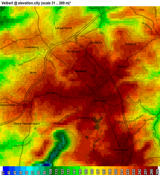
Below is the Elevation map of Velbert, which displays elevation range with different colors. Scale of the first map is from 31 to 269 m (102 to 883 ft) with average elevation of 208.4 meters (=684 ft) [note 1]
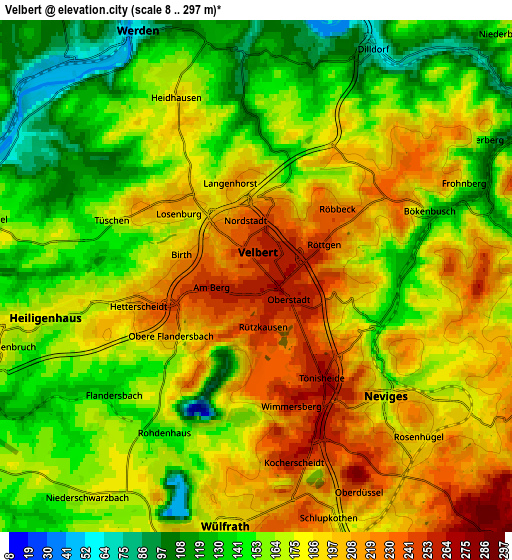
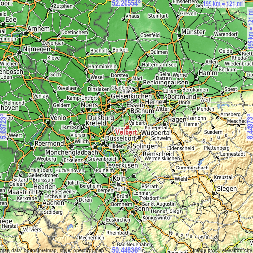
These maps also provides idea of topography and contour of this city, they are displayed at different zoom levels. More info about maps, scale and edge coordinates you can find below images.
| \ | Map #1 | Map #2 | Topo.Map |
| Scale [m] | 31..269 m | 8..297 m | × |
| Scale [ft] | 102..883 ft | 26..974 ft | × |
| Average | 208.4 m = 684 ft | 173 m = 568 ft | × |
| Width | 6.11 km = 3.8 mi | 12.21 km = 7.6 mi | 195.4 km = 121.4 mi |
| Height | 6.11 km = 3.8 mi | 12.21 km = 7.6 mi | 195.4 km = 121.4 mi |
| ↑Max Latitude | 51.362817° | 51.390248° | 52.20554° |
| Latitude at center | 51.33537° | 51.33537° | 51.33537° |
| ↓Min Latitude | 51.307906° | 51.280426° | 50.44836° |
| ← Min Longitude | 6.999535° | 6.955589° | 5.63723° |
| Longitude center | 7.04348° | 7.04348° | 7.04348° |
| →Max Longitude | 7.087425° | 7.131371° | 8.44973° |
Nearby cities:
Cities around Velbert sort by population:
• Essen elevation 83 m
13.6 km,  350°
350°
• Wuppertal 176 m
11.4 km,  140°
140°
• Mülheim 40 m
15.7 km,  313°
313°
• Ratingen 64 m
14.1 km,  252°
252°
• Hattingen 100 m
12.1 km,  54°
54°
• Erkrath 56 m
15.7 km,  216°
216°
• Mettmann 132 m
10.6 km,  206°
206°
• Schwelm 229 m
18.2 km,  107°
107°
• Haan 168 m
15.9 km,  187°
187°
• Heiligenhaus 180 m
5.1 km,  259°
259°
• Sprockhövel 228 m
13.9 km,  84°
84°
• Wülfrath 189 m
6 km,  183°
183°
Multilingual:
 En español:
Velbert elevación 245 m.
 En France:
Velbert élévation 245 m.


Sources and notes:
- [note 1] Map square and city borders are not equal. Map elevation data is calculated only from area inside that square.
- [src 1] Elevation data from geonames database provided with same terms of usage.
- [src 2] The elevation map of Velbert is generated using elevation data from NASA's 3 arcsec (90m) resolution SRTM data.
- [src 3] Base (background) map © OpenStreetMap contributors tiles are generated by Geofabrik and OpenTopoMap.
Copyright & License:
This Velbert Elevation Map is licensed under CC BY-SA. You may reuse any part from this page, if you give a proper credit by linking to this URL:
 More info on terms of use page.