Hattingen elevation
Hattingen (North Rhine-Westphalia, Regierungsbezirk Arnsberg), Germany elevation is 100 meters and Hattingen elevation in feet is 328 ft above sea level [src 1]. Hattingen is a populated place (feature code) with elevation that is 158 meters (518 ft) smaller than average city elevation in Germany.
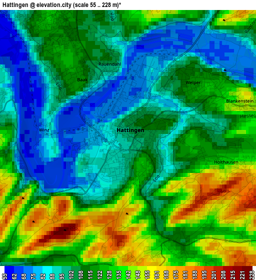
Below is the Elevation map of Hattingen, which displays elevation range with different colors. Scale of the first map is from 55 to 228 m (180 to 748 ft) with average elevation of 114.2 meters (=375 ft) [note 1]
These maps also provides idea of topography and contour of this city, they are displayed at different zoom levels. More info about maps, scale and edge coordinates you can find below images.
| \ | Map #1 | Map #2 | Topo.Map |
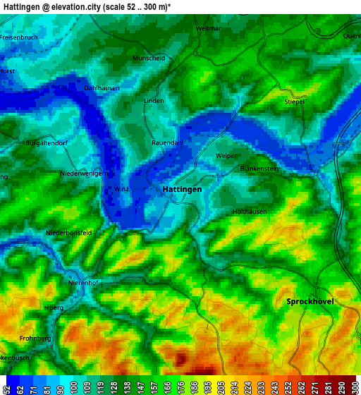
| Scale [m] | 55..228 m | 52..300 m | × |
| Scale [ft] | 180..748 ft | 171..984 ft | × |
| Average | 114.2 m = 375 ft | 139 m = 456 ft | × |
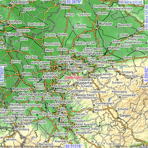
| Width | 6.1 km = 3.8 mi | 12.19 km = 7.6 mi | 195.1 km = 121.2 mi |
| Height | 6.1 km = 3.8 mi | 12.19 km = 7.6 mi | 195.1 km = 121.2 mi |
| ↑Max Latitude | 51.426349° | 51.453742° | 52.2679° |
| Latitude at center | 51.39894° | 51.39894° | 51.39894° |
| ↓Min Latitude | 51.371515° | 51.344073° | 50.51316° |
| ← Min Longitude | 7.141625° | 7.097679° | 5.77932° |
| Longitude center | 7.18557° | 7.18557° | 7.18557° |
| →Max Longitude | 7.229515° | 7.273461° | 8.59182° |
Nearby cities:
Cities around Hattingen sort by population:
• Essen elevation 83 m
13.6 km,  298°
298°
• Bochum 102 m
9.4 km,  13°
13°
• Bochum-Hordel 57 m
11.4 km,  356°
356°
• Gelsenkirchen 48 m
13.3 km,  332°
332°
• Herne 67 m
15.8 km, 10°
• Witten 119 m
12.6 km,  66°
66°
• Velbert 245 m
12.1 km,  234°
234°
• Gevelsberg 166 m
13.8 km,  129°
129°
• Schwelm 229 m
14.6 km,  148°
148°
• Wetter (Ruhr) 126 m
14.4 km,  95°
95°
• Sprockhövel 228 m
7.1 km, 145°
• Hordel 69 m
11 km, 356°
Multilingual:
 En español:
Hattingen elevación 100 m.
 En France:
Hattingen élévation 100 m.
 Auf Deutsch:
Hattingen höhe über dem Meeresspiegel ist 100 m.

Sources and notes:
- [note 1] Map square and city borders are not equal. Map elevation data is calculated only from area inside that square.
- [src 1] Elevation data from geonames database provided with same terms of usage.
- [src 2] The elevation map of Hattingen is generated using elevation data from NASA's 3 arcsec (90m) resolution SRTM data.
- [src 3] Base (background) map © OpenStreetMap contributors tiles are generated by Geofabrik and OpenTopoMap.
Copyright & License:
This Hattingen Elevation Map is licensed under CC BY-SA. You may reuse any part from this page, if you give a proper credit by linking to this URL:
 More info on terms of use page.