Mülheim elevation
Mülheim (North Rhine-Westphalia, Düsseldorf District), Germany elevation is 40 meters and Mülheim elevation in feet is 131 ft above sea level [src 1]. Mülheim is a populated place (feature code) with elevation that is 218 meters (715 ft) smaller than average city elevation in Germany.
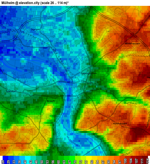
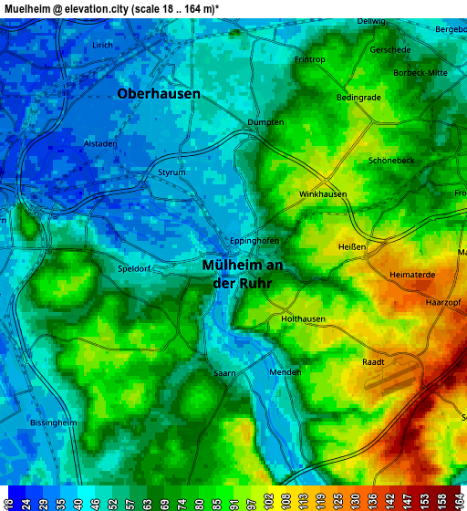
Below is the Elevation map of Mülheim, which displays elevation range with different colors. Scale of the first map is from 26 to 114 m (85 to 374 ft) with average elevation of 63.4 meters (=208 ft) [note 1]
These maps also provides idea of topography and contour of this city, they are displayed at different zoom levels. More info about maps, scale and edge coordinates you can find below images.

| \ | Map #1 | Map #2 | Topo.Map |
| Scale [m] | 26..114 m | 18..164 m | × |
| Scale [ft] | 85..374 ft | 59..538 ft | × |
| Average | 63.4 m = 208 ft | 66.9 m = 219 ft | × |
| Width | 6.09 km = 3.8 mi | 12.19 km = 7.6 mi | 195 km = 121.2 mi |
| Height | 6.09 km = 3.8 mi | 12.19 km = 7.6 mi | 195 km = 121.2 mi |
| ↑Max Latitude | 51.459569° | 51.486942° | 52.3005° |
| Latitude at center | 51.43218° | 51.43218° | 51.43218° |
| ↓Min Latitude | 51.404774° | 51.377353° | 50.54704° |
| ← Min Longitude | 6.835725° | 6.791779° | 5.47342° |
| Longitude center | 6.87967° | 6.87967° | 6.87967° |
| →Max Longitude | 6.923615° | 6.967561° | 8.28592° |
Nearby cities:
Cities around Mülheim sort by population:
• Essen elevation 83 m
9.6 km,  73°
73°
• Duisburg 38 m
7.9 km,  270°
270°
• Gelsenkirchen 48 m
17.1 km,  61°
61°
• Oberhausen 44 m
5.2 km,  346°
346°
• Bottrop 55 m
10.7 km,  18°
18°
• Moers 29 m
17.3 km,  277°
277°
• Ratingen 64 m
15.2 km,  188°
188°
• Velbert 245 m
15.7 km,  133°
133°
• Gladbeck 60 m
17.1 km,  25°
25°
• Meiderich 30 m
8.7 km,  296°
296°
• Heiligenhaus 180 m
13.3 km,  151°
151°
• Hochfeld 36 m
8.8 km,  260°
260°
Multilingual:
 En español:
Mülheim an der Ruhr elevación 40 m.
 En France:
Mülheim an der Ruhr élévation 40 m.
 Auf Deutsch:
Mülheim (Ruhr) höhe über dem Meeresspiegel ist 40 m.

Sources and notes:
- [note 1] Map square and city borders are not equal. Map elevation data is calculated only from area inside that square.
- [src 1] Elevation data from geonames database provided with same terms of usage.
- [src 2] The elevation map of Mülheim is generated using elevation data from NASA's 3 arcsec (90m) resolution SRTM data.
- [src 3] Base (background) map © OpenStreetMap contributors tiles are generated by Geofabrik and OpenTopoMap.
Copyright & License:
This Mülheim Elevation Map is licensed under CC BY-SA. You may reuse any part from this page, if you give a proper credit by linking to this URL:
 More info on terms of use page.