Haan elevation
Haan (North Rhine-Westphalia, Düsseldorf District), Germany elevation is 168 meters and Haan elevation in feet is 551 ft above sea level [src 1]. Haan is a populated place (feature code) with elevation that is 90 meters (295 ft) smaller than average city elevation in Germany.
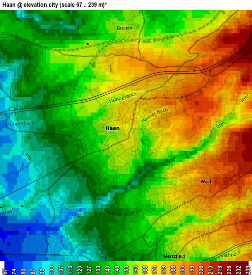
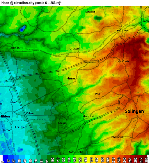
Below is the Elevation map of Haan, which displays elevation range with different colors. Scale of the first map is from 67 to 239 m (220 to 784 ft) with average elevation of 150.6 meters (=494 ft) [note 1]
These maps also provides idea of topography and contour of this city, they are displayed at different zoom levels. More info about maps, scale and edge coordinates you can find below images.
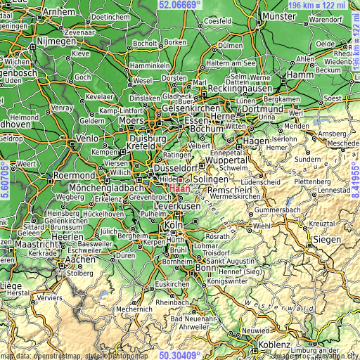
| \ | Map #1 | Map #2 | Topo.Map |
| Scale [m] | 67..239 m | 6..283 m | × |
| Scale [ft] | 220..784 ft | 20..928 ft | × |
| Average | 150.6 m = 494 ft | 144.6 m = 474 ft | × |
| Width | 6.12 km = 3.8 mi | 12.25 km = 7.6 mi | 196 km = 121.8 mi |
| Height | 6.12 km = 3.8 mi | 12.25 km = 7.6 mi | 196 km = 121.8 mi |
| ↑Max Latitude | 51.221352° | 51.248867° | 52.06669° |
| Latitude at center | 51.19382° | 51.19382° | 51.19382° |
| ↓Min Latitude | 51.166272° | 51.138707° | 50.30409° |
| ← Min Longitude | 6.969355° | 6.925409° | 5.60705° |
| Longitude center | 7.0133° | 7.0133° | 7.0133° |
| →Max Longitude | 7.057245° | 7.101191° | 8.41955° |
Nearby cities:
Cities around Haan sort by population:
• Wuppertal elevation 176 m
11.7 km,  53°
53°
• Solingen 229 m
5.5 km,  114°
114°
• Remscheid 351 m
12.6 km,  97°
97°
• Langenfeld 51 m
10.5 km,  205°
205°
• Hilden 52 m
6.4 km,  243°
243°
• Erkrath 56 m
8 km,  293°
293°
• Monheim am Rhein 44 m
14.2 km,  216°
216°
• Mettmann 132 m
6.8 km,  337°
337°
• Leichlingen 63 m
9.7 km,  177°
177°
• Opladen 55 m
13.9 km, 182°
• Wülfrath 189 m
10 km,  10°
10°
• Burscheid 191 m
14 km,  149°
149°
Multilingual:
 En español:
Haan elevación 168 m.
 En France:
Haan élévation 168 m.


Sources and notes:
- [note 1] Map square and city borders are not equal. Map elevation data is calculated only from area inside that square.
- [src 1] Elevation data from geonames database provided with same terms of usage.
- [src 2] The elevation map of Haan is generated using elevation data from NASA's 3 arcsec (90m) resolution SRTM data.
- [src 3] Base (background) map © OpenStreetMap contributors tiles are generated by Geofabrik and OpenTopoMap.
Copyright & License:
This Haan Elevation Map is licensed under CC BY-SA. You may reuse any part from this page, if you give a proper credit by linking to this URL:
 More info on terms of use page.