Langenfeld elevation
Langenfeld (North Rhine-Westphalia, Düsseldorf District), Germany elevation is 51 meters and Langenfeld elevation in feet is 167 ft above sea level [src 1]. Langenfeld is a populated place (feature code) with elevation that is 207 meters (679 ft) smaller than average city elevation in Germany.
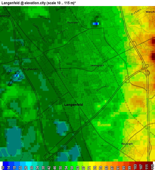
Below is the Elevation map of Langenfeld, which displays elevation range with different colors. Scale of the first map is from 10 to 115 m (33 to 377 ft) with average elevation of 53.8 meters (=177 ft) [note 1]
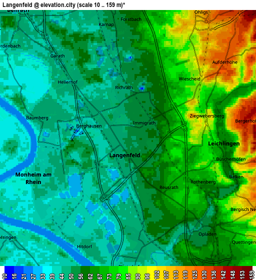
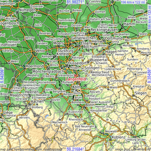
These maps also provides idea of topography and contour of this city, they are displayed at different zoom levels. More info about maps, scale and edge coordinates you can find below images.
| \ | Map #1 | Map #2 | Topo.Map |
| Scale [m] | 10..115 m | 10..159 m | × |
| Scale [ft] | 33..377 ft | 33..522 ft | × |
| Average | 53.8 m = 177 ft | 60.3 m = 198 ft | × |
| Width | 6.14 km = 3.8 mi | 12.27 km = 7.6 mi | 196.3 km = 122 mi |
| Height | 6.14 km = 3.8 mi | 12.27 km = 7.6 mi | 196.3 km = 122 mi |
| ↑Max Latitude | 51.135793° | 51.163359° | 51.98271° |
| Latitude at center | 51.10821° | 51.10821° | 51.10821° |
| ↓Min Latitude | 51.080611° | 51.052995° | 50.21684° |
| ← Min Longitude | 6.904365° | 6.860419° | 5.54206° |
| Longitude center | 6.94831° | 6.94831° | 6.94831° |
| →Max Longitude | 6.992255° | 7.036201° | 8.35456° |
Nearby cities:
Cities around Langenfeld sort by population:
• Solingen elevation 229 m
12 km,  52°
52°
• Leverkusen 52 m
9 km,  163°
163°
• Dormagen 45 m
8.2 km,  261°
261°
• Hilden 52 m
6.8 km,  349°
349°
• Erkrath 56 m
13 km, 347°
• Monheim am Rhein 44 m
4.3 km,  244°
244°
• Haan 168 m
10.5 km,  25°
25°
• Leichlingen 63 m
4.9 km,  92°
92°
• Opladen 55 m
5.9 km,  138°
138°
• Burscheid 191 m
11.9 km,  102°
102°
• Odenthal 83 m
14.4 km,  125°
125°
• Sinnersdorf 46 m
13 km,  224°
224°
Multilingual:
 En español:
Langenfeld elevación 51 m.
 En France:
Langenfeld élévation 51 m.
 Auf Deutsch:
Langenfeld höhe über dem Meeresspiegel ist 51 m.

Sources and notes:
- [note 1] Map square and city borders are not equal. Map elevation data is calculated only from area inside that square.
- [src 1] Elevation data from geonames database provided with same terms of usage.
- [src 2] The elevation map of Langenfeld is generated using elevation data from NASA's 3 arcsec (90m) resolution SRTM data.
- [src 3] Base (background) map © OpenStreetMap contributors tiles are generated by Geofabrik and OpenTopoMap.
Copyright & License:
This Langenfeld Elevation Map is licensed under CC BY-SA. You may reuse any part from this page, if you give a proper credit by linking to this URL:
 More info on terms of use page.