Weißenberg elevation
Weißenberg (Saxony), Germany elevation is 197 meters and Weißenberg elevation in feet is 646 ft above sea level [src 1]. Weißenberg is a populated place (feature code) with elevation that is 61 meters (200 ft) smaller than average city elevation in Germany.
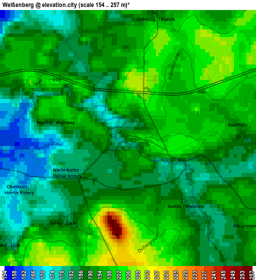
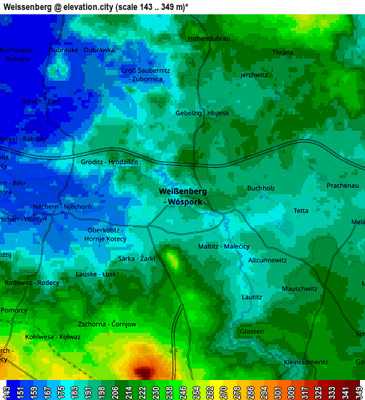
Below is the Elevation map of Weißenberg, which displays elevation range with different colors. Scale of the first map is from 154 to 257 m (505 to 843 ft) with average elevation of 191.2 meters (=627 ft) [note 1]
These maps also provides idea of topography and contour of this city, they are displayed at different zoom levels. More info about maps, scale and edge coordinates you can find below images.
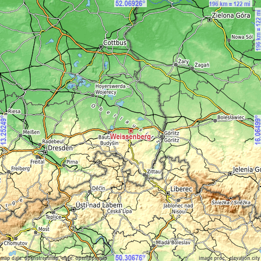
| \ | Map #1 | Map #2 | Topo.Map |
| Scale [m] | 154..257 m | 143..349 m | × |
| Scale [ft] | 505..843 ft | 469..1145 ft | × |
| Average | 191.2 m = 627 ft | 197.3 m = 647 ft | × |
| Width | 6.12 km = 3.8 mi | 12.25 km = 7.6 mi | 196 km = 121.8 mi |
| Height | 6.12 km = 3.8 mi | 12.25 km = 7.6 mi | 196 km = 121.8 mi |
| ↑Max Latitude | 51.22397° | 51.251484° | 52.06926° |
| Latitude at center | 51.19644° | 51.19644° | 51.19644° |
| ↓Min Latitude | 51.168893° | 51.14133° | 50.30676° |
| ← Min Longitude | 14.614795° | 14.570849° | 13.25249° |
| Longitude center | 14.65874° | 14.65874° | 14.65874° |
| →Max Longitude | 14.702685° | 14.746631° | 16.06499° |
Nearby cities:
Cities around Weißenberg sort by population:
• Löbau elevation 272 m
10.8 km,  176°
176°
• Reichenbach 245 m
11.8 km,  121°
121°
• Malschwitz 149 m
10.6 km,  295°
295°
• Kubschütz 219 m
11.5 km,  253°
253°
• Hochkirch 289 m
8.1 km,  229°
229°
• Lawalde 334 m
13.2 km,  198°
198°
• Guttau 145 m
9.7 km,  315°
315°
• Quitzdorf 159 m
12.2 km,  37°
37°
• Sohland am Rotstein 244 m
12.5 km,  135°
135°
• Großschweidnitz 279 m
14.2 km, 184°
• Königshain 246 m
14.6 km,  95°
95°
• Mücka 149 m
13.7 km,  12°
12°
Multilingual:
 En español:
Weißenberg elevación 197 m.
 En France:
Weißenberg élévation 197 m.
 Auf Deutsch:
Weißenberg höhe über dem Meeresspiegel ist 197 m.

Sources and notes:
- [note 1] Map square and city borders are not equal. Map elevation data is calculated only from area inside that square.
- [src 1] Elevation data from geonames database provided with same terms of usage.
- [src 2] The elevation map of Weißenberg is generated using elevation data from NASA's 3 arcsec (90m) resolution SRTM data.
- [src 3] Base (background) map © OpenStreetMap contributors tiles are generated by Geofabrik and OpenTopoMap.
Copyright & License:
This Weißenberg Elevation Map is licensed under CC BY-SA. You may reuse any part from this page, if you give a proper credit by linking to this URL:
 More info on terms of use page.