Mücka elevation
Mücka (Saxony), Germany elevation is 149 meters and Mücka elevation in feet is 489 ft above sea level [src 1]. Mücka is a seat of a fourth-order administrative division (feature code) with elevation that is 109 meters (358 ft) smaller than average city elevation in Germany.
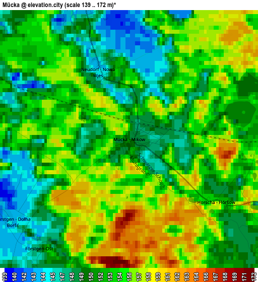
Below is the Elevation map of Mücka, which displays elevation range with different colors. Scale of the first map is from 139 to 172 m (456 to 564 ft) with average elevation of 152.9 meters (=502 ft) [note 1]
These maps also provides idea of topography and contour of this city, they are displayed at different zoom levels. More info about maps, scale and edge coordinates you can find below images.
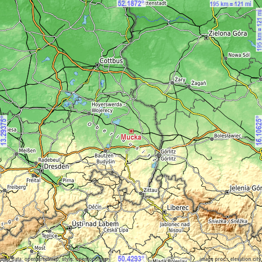
| \ | Map #1 | Topo.Map |
| Scale [m] | 139..172 m | × |
| Scale [ft] | 456..564 ft | × |
| Average | 152.9 m = 502 ft | × |
| Width | 6.11 km = 3.8 mi | 195.5 km = 121.5 mi |
| Height | 6.11 km = 3.8 mi | 195.4 km = 121.4 mi |
| ↑Max Latitude | 51.344128° | 52.1872° |
| Latitude at center | 51.31667° | 51.31667° |
| ↓Min Latitude | 51.289195° | 50.4293° |
| ← Min Longitude | 14.656055° | 13.29375° |
| Longitude center | 14.7° | 14.7° |
| →Max Longitude | 14.743945° | 16.10625° |
Nearby cities:
Cities around Mücka sort by population:
• Niesky elevation 183 m
8.8 km,  107°
107°
• Großdubrau 197 m
18.1 km,  247°
247°
• Malschwitz 149 m
15.2 km,  234°
234°
• Weißenberg 197 m
13.7 km,  192°
192°
• Boxberg 132 m
13 km,  318°
318°
• Rietschen 142 m
10.9 km,  31°
31°
• Kodersdorf 180 m
15.8 km,  121°
121°
• Guttau 145 m
11.6 km,  236°
236°
• Quitzdorf 159 m
5.9 km,  128°
128°
• Hähnichen 153 m
12.4 km,  64°
64°
• Klitten 135 m
7.6 km,  300°
300°
• Uhyst 131 m
14.5 km,  291°
291°
Multilingual:
 En español:
Mücka elevación 149 m.
 En France:
Mücka élévation 149 m.


Sources and notes:
- [note 1] Map square and city borders are not equal. Map elevation data is calculated only from area inside that square.
- [src 1] Elevation data from geonames database provided with same terms of usage.
- [src 2] The elevation map of Mücka is generated using elevation data from NASA's 3 arcsec (90m) resolution SRTM data.
- [src 3] Base (background) map © OpenStreetMap contributors tiles are generated by Geofabrik and OpenTopoMap.
Copyright & License:
This Mücka Elevation Map is licensed under CC BY-SA. You may reuse any part from this page, if you give a proper credit by linking to this URL:
 More info on terms of use page.