Königshain elevation
Königshain (Saxony), Germany elevation is 246 meters and Königshain elevation in feet is 807 ft above sea level [src 1]. Königshain is a seat of a fourth-order administrative division (feature code) with elevation that is 12 meters (39 ft) smaller than average city elevation in Germany.
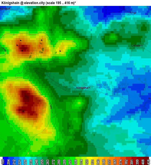
Below is the Elevation map of Königshain, which displays elevation range with different colors. Scale of the first map is from 195 to 416 m (640 to 1365 ft) with average elevation of 269.4 meters (=884 ft) [note 1]
These maps also provides idea of topography and contour of this city, they are displayed at different zoom levels. More info about maps, scale and edge coordinates you can find below images.
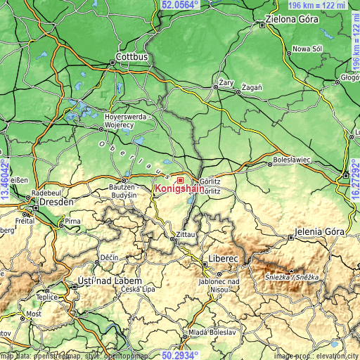
| \ | Map #1 | Topo.Map |
| Scale [m] | 195..416 m | × |
| Scale [ft] | 640..1365 ft | × |
| Average | 269.4 m = 884 ft | × |
| Width | 6.13 km = 3.8 mi | 196 km = 121.8 mi |
| Height | 6.13 km = 3.8 mi | 196 km = 121.8 mi |
| ↑Max Latitude | 51.210868° | 52.0564° |
| Latitude at center | 51.18333° | 51.18333° |
| ↓Min Latitude | 51.155776° | 50.2934° |
| ← Min Longitude | 14.822725° | 13.46042° |
| Longitude center | 14.86667° | 14.86667° |
| →Max Longitude | 14.910615° | 16.27292° |
Nearby cities:
Cities around Königshain sort by population:
• Görlitz elevation 210 m
9.1 km,  110°
110°
• Löbau 272 m
16.7 km,  236°
236°
• Niesky 183 m
12.5 km,  345°
345°
• Rothenburg 163 m
18.2 km,  22°
22°
• Reichenbach 245 m
6.4 km,  223°
223°
• Markersdorf 247 m
5.7 km,  168°
168°
• Bernstadt 233 m
15.4 km,  190°
190°
• Weißenberg 197 m
14.6 km,  275°
275°
• Kodersdorf 180 m
6.9 km, 15°
• Schönau-Berzdorf 217 m
13.3 km, 174°
• Quitzdorf 159 m
13.1 km,  327°
327°
• Sohland am Rotstein 244 m
9.4 km, 217°
Multilingual:
 En español:
Königshain elevación 246 m.
 En France:
Königshain élévation 246 m.
 Auf Deutsch:
Königshain höhe über dem Meeresspiegel ist 246 m.

Sources and notes:
- [note 1] Map square and city borders are not equal. Map elevation data is calculated only from area inside that square.
- [src 1] Elevation data from geonames database provided with same terms of usage.
- [src 2] The elevation map of Königshain is generated using elevation data from NASA's 3 arcsec (90m) resolution SRTM data.
- [src 3] Base (background) map © OpenStreetMap contributors tiles are generated by Geofabrik and OpenTopoMap.
Copyright & License:
This Königshain Elevation Map is licensed under CC BY-SA. You may reuse any part from this page, if you give a proper credit by linking to this URL:
 More info on terms of use page.