Rothenburg elevation
Rothenburg (Saxony), Germany elevation is 163 meters and Rothenburg elevation in feet is 535 ft above sea level [src 1]. Rothenburg is a populated place (feature code) with elevation that is 95 meters (312 ft) smaller than average city elevation in Germany.
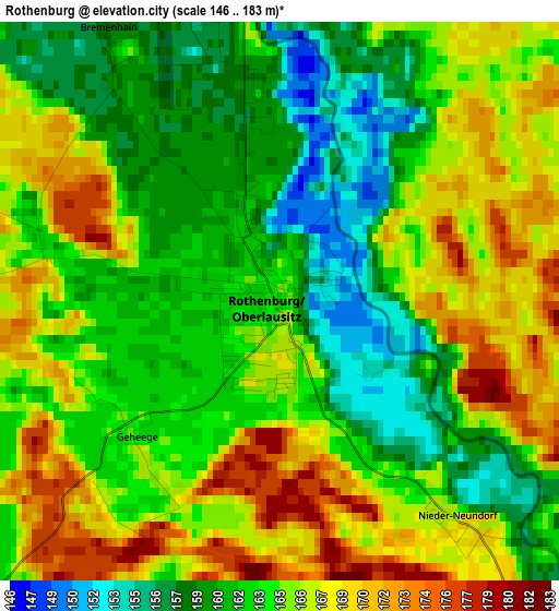
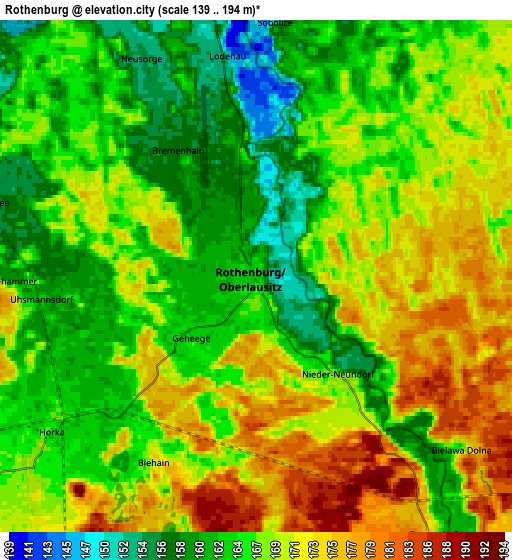
Below is the Elevation map of Rothenburg, which displays elevation range with different colors. Scale of the first map is from 146 to 183 m (479 to 600 ft) with average elevation of 164.2 meters (=539 ft) [note 1]
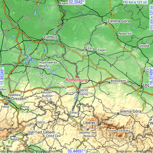
These maps also provides idea of topography and contour of this city, they are displayed at different zoom levels. More info about maps, scale and edge coordinates you can find below images.
| \ | Map #1 | Map #2 | Topo.Map |
| Scale [m] | 146..183 m | 139..194 m | × |
| Scale [ft] | 479..600 ft | 456..636 ft | × |
| Average | 164.2 m = 539 ft | 167.4 m = 549 ft | × |
| Width | 6.11 km = 3.8 mi | 12.21 km = 7.6 mi | 195.4 km = 121.4 mi |
| Height | 6.11 km = 3.8 mi | 12.21 km = 7.6 mi | 195.4 km = 121.4 mi |
| ↑Max Latitude | 51.361448° | 51.388879° | 52.2042° |
| Latitude at center | 51.334° | 51.334° | 51.334° |
| ↓Min Latitude | 51.306536° | 51.279055° | 50.44697° |
| ← Min Longitude | 14.924795° | 14.880849° | 13.56249° |
| Longitude center | 14.96874° | 14.96874° | 14.96874° |
| →Max Longitude | 15.012685° | 15.056631° | 16.37499° |
Nearby cities:
Cities around Rothenburg sort by population:
• Görlitz elevation 210 m
19.9 km,  176°
176°
• Niesky 183 m
11.3 km,  245°
245°
• Reichenbach 245 m
24.3 km,  208°
208°
• Markersdorf 247 m
23.1 km,  194°
194°
• Rietschen 142 m
14.8 km,  299°
299°
• Kodersdorf 180 m
11.4 km, 207°
• Quitzdorf 159 m
15.1 km, 248°
• Hähnichen 153 m
8.3 km, 295°
• Klitten 135 m
25.3 km,  274°
274°
• Weißkeißel 124 m
25 km,  315°
315°
• Königshain 246 m
18.2 km,  202°
202°
• Mücka 149 m
18.8 km,  264°
264°
Multilingual:
 En español:
Rothenburg elevación 163 m.
 En France:
Rothenburg élévation 163 m.
 Auf Deutsch:
Rothenburg höhe über dem Meeresspiegel ist 163 m.

Sources and notes:
- [note 1] Map square and city borders are not equal. Map elevation data is calculated only from area inside that square.
- [src 1] Elevation data from geonames database provided with same terms of usage.
- [src 2] The elevation map of Rothenburg is generated using elevation data from NASA's 3 arcsec (90m) resolution SRTM data.
- [src 3] Base (background) map © OpenStreetMap contributors tiles are generated by Geofabrik and OpenTopoMap.
Copyright & License:
This Rothenburg Elevation Map is licensed under CC BY-SA. You may reuse any part from this page, if you give a proper credit by linking to this URL:
 More info on terms of use page.