Großschweidnitz elevation
Großschweidnitz (Saxony), Germany elevation is 279 meters and Großschweidnitz elevation in feet is 915 ft above sea level [src 1]. Großschweidnitz is a seat of a fourth-order administrative division (feature code) with elevation that is 21 meters (69 ft) bigger than average city elevation in Germany.
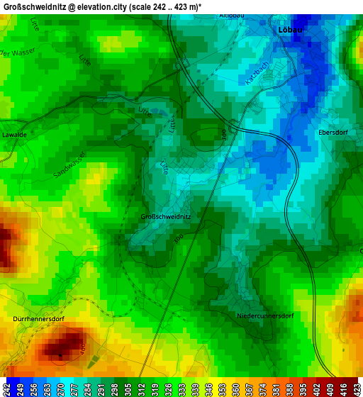
Below is the Elevation map of Großschweidnitz, which displays elevation range with different colors. Scale of the first map is from 242 to 423 m (794 to 1388 ft) with average elevation of 311.2 meters (=1021 ft) [note 1]
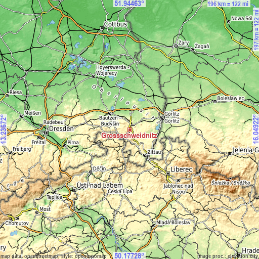
These maps also provides idea of topography and contour of this city, they are displayed at different zoom levels. More info about maps, scale and edge coordinates you can find below images.
| \ | Map #1 | Topo.Map |
| Scale [m] | 242..423 m | × |
| Scale [ft] | 794..1388 ft | × |
| Average | 311.2 m = 1021 ft | × |
| Width | 6.14 km = 3.8 mi | 196.5 km = 122.1 mi |
| Height | 6.14 km = 3.8 mi | 196.5 km = 122.1 mi |
| ↑Max Latitude | 51.096996° | 51.94463° |
| Latitude at center | 51.06939° | 51.06939° |
| ↓Min Latitude | 51.041767° | 50.17728° |
| ← Min Longitude | 14.599025° | 13.23672° |
| Longitude center | 14.64297° | 14.64297° |
| →Max Longitude | 14.686915° | 16.04922° |
Nearby cities:
Cities around Großschweidnitz sort by population:
• Löbau elevation 272 m
3.8 km,  26°
26°
• Ebersbach 358 m
7.9 km,  210°
210°
• Cunewalde 290 m
9.5 km,  291°
291°
• Eibau 358 m
9.7 km,  172°
172°
• Herrnhut 342 m
9.2 km,  129°
129°
• Neusalza-Spremberg 310 m
8.2 km,  246°
246°
• Lawalde 334 m
3.4 km,  297°
297°
• Niedercunnersdorf 287 m
2 km,  147°
147°
• Friedersdorf 335 m
7.5 km,  228°
228°
• Beiersdorf 386 m
7.3 km,  274°
274°
• Schönbach 402 m
5.3 km, 266°
• Dürrhennersdorf 346 m
3.6 km, 229°
Multilingual:
 En español:
Großschweidnitz elevación 279 m.
 En France:
Großschweidnitz élévation 279 m.
 Auf Deutsch:
Großschweidnitz höhe über dem Meeresspiegel ist 279 m.

Sources and notes:
- [note 1] Map square and city borders are not equal. Map elevation data is calculated only from area inside that square.
- [src 1] Elevation data from geonames database provided with same terms of usage.
- [src 2] The elevation map of Großschweidnitz is generated using elevation data from NASA's 3 arcsec (90m) resolution SRTM data.
- [src 3] Base (background) map © OpenStreetMap contributors tiles are generated by Geofabrik and OpenTopoMap.
Copyright & License:
This Großschweidnitz Elevation Map is licensed under CC BY-SA. You may reuse any part from this page, if you give a proper credit by linking to this URL:
 More info on terms of use page.