Chiquinquirá elevation
Chiquinquirá (Boyacá), Colombia elevation is 2562 meters and Chiquinquirá elevation in feet is 8406 ft above sea level [src 1]. Chiquinquirá is a seat of a second-order administrative division (feature code) with elevation that is 1413 meters (4636 ft) bigger than average city elevation in Colombia.
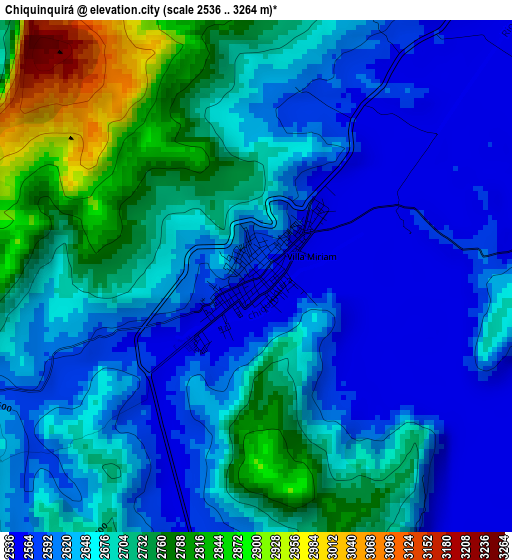
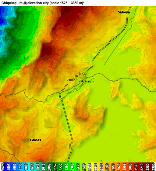
Below is the Elevation map of Chiquinquirá, which displays elevation range with different colors. Scale of the first map is from 2536 to 3264 m (8320 to 10709 ft) with average elevation of 2664.4 meters (=8741 ft) [note 1]
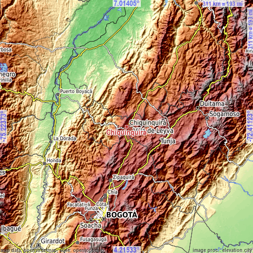
These maps also provides idea of topography and contour of this city, they are displayed at different zoom levels. More info about maps, scale and edge coordinates you can find below images.
| \ | Map #1 | Map #2 | Topo.Map |
| Scale [m] | 2536..3264 m | 1525..3350 m | × |
| Scale [ft] | 8320..10709 ft | 5003..10991 ft | × |
| Average | 2664.4 m = 8741 ft | 2638.1 m = 8655 ft | × |
| Width | 9.73 km = 6 mi | 19.45 km = 12.1 mi | 311.2 km = 193.4 mi |
| Height | 9.73 km = 6 mi | 19.45 km = 12.1 mi | 311.2 km = 193.4 mi |
| ↑Max Latitude | 5.660103° | 5.703832° | 7.01405° |
| Latitude at center | 5.61637° | 5.61637° | 5.61637° |
| ↓Min Latitude | 5.572634° | 5.528895° | 4.21533° |
| ← Min Longitude | -73.861425° | -73.905371° | -75.22373° |
| Longitude center | -73.81748° | -73.81748° | -73.81748° |
| →Max Longitude | -73.773535° | -73.729589° | -72.41123° |
Nearby cities:
Cities around Chiquinquirá sort by population:
• Simijaca elevation 2563 m
13.2 km,  196°
196°
• Pauna 1080 m
18.9 km,  284°
284°
• Susa 2561 m
18.3 km,  178°
178°
• Sutamarchán 2085 m
22.2 km,  90°
90°
• Saboyá 2640 m
10.4 km,  30°
30°
• Albania 1282 m
19.1 km,  326°
326°
• San Miguel de Sema 2605 m
15.1 km,  135°
135°
• Briceño 1358 m
13.7 km,  305°
305°
• Caldas 2671 m
8.7 km,  217°
217°
• Tinjacá 2106 m
19.5 km,  102°
102°
• Tununguá 1150 m
18.6 km, 312°
• Buenavista 2123 m
18.5 km,  231°
231°
Multilingual:
 En español:
Chiquinquirá elevación 2562 m.
 En France:
Chiquinquirá élévation 2562 m.
 Auf Deutsch:
Chiquinquirá höhe über dem Meeresspiegel ist 2562 m.

Sources and notes:
- [note 1] Map square and city borders are not equal. Map elevation data is calculated only from area inside that square.
- [src 1] Elevation data from geonames database provided with same terms of usage.
- [src 2] The elevation map of Chiquinquirá is generated using elevation data from NASA's 3 arcsec (90m) resolution SRTM data.
- [src 3] Base (background) map © OpenStreetMap contributors tiles are generated by Geofabrik and OpenTopoMap.
Copyright & License:
This Chiquinquirá Elevation Map is licensed under CC BY-SA. You may reuse any part from this page, if you give a proper credit by linking to this URL:
 More info on terms of use page.