San Miguel de Sema elevation
San Miguel de Sema (Boyacá), Colombia elevation is 2605 meters and San Miguel de Sema elevation in feet is 8547 ft above sea level [src 1]. San Miguel de Sema is a seat of a second-order administrative division (feature code) with elevation that is 1456 meters (4777 ft) bigger than average city elevation in Colombia.
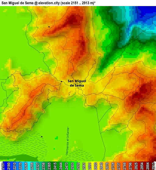
Below is the Elevation map of San Miguel de Sema, which displays elevation range with different colors. Scale of the first map is from 2151 to 2913 m (7057 to 9557 ft) with average elevation of 2588.2 meters (=8491 ft) [note 1]
These maps also provides idea of topography and contour of this city, they are displayed at different zoom levels. More info about maps, scale and edge coordinates you can find below images.
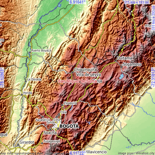
| \ | Map #1 | Topo.Map |
| Scale [m] | 2151..2913 m | × |
| Scale [ft] | 7057..9557 ft | × |
| Average | 2588.2 m = 8491 ft | × |
| Width | 9.73 km = 6 mi | 311.2 km = 193.4 mi |
| Height | 9.73 km = 6 mi | 311.3 km = 193.4 mi |
| ↑Max Latitude | 5.56221° | 6.91641° |
| Latitude at center | 5.51847° | 5.51847° |
| ↓Min Latitude | 5.474727° | 4.11722° |
| ← Min Longitude | -73.766325° | -75.12863° |
| Longitude center | -73.72238° | -73.72238° |
| →Max Longitude | -73.678435° | -72.31613° |
Nearby cities:
Cities around San Miguel de Sema sort by population:
• Chiquinquirá elevation 2562 m
15.1 km,  315°
315°
• Simijaca 2563 m
14.5 km,  263°
263°
• Guachetá 2684 m
15.5 km,  164°
164°
• Lenguazaque 2577 m
23.5 km,  177°
177°
• Ráquira 2165 m
10.2 km,  77°
77°
• Sáchica 2153 m
21.3 km,  69°
69°
• Susa 2561 m
12.6 km,  233°
233°
• Sutamarchán 2085 m
15.9 km,  47°
47°
• Saboyá 2640 m
20.5 km,  345°
345°
• Fúquene 2866 m
15.1 km,  212°
212°
• Caldas 2671 m
16.4 km,  284°
284°
• Tinjacá 2106 m
10.9 km, 51°
Multilingual:
 En español:
San Miguel de Sema elevación 2605 m.
 En France:
San Miguel de Sema élévation 2605 m.
 Auf Deutsch:
San Miguel de Sema höhe über dem Meeresspiegel ist 2605 m.
 На русском:
San Miguel de Sema высота над уровнем моря 2605 м
Sources and notes:
- [note 1] Map square and city borders are not equal. Map elevation data is calculated only from area inside that square.
- [src 1] Elevation data from geonames database provided with same terms of usage.
- [src 2] The elevation map of San Miguel de Sema is generated using elevation data from NASA's 3 arcsec (90m) resolution SRTM data.
- [src 3] Base (background) map © OpenStreetMap contributors tiles are generated by Geofabrik and OpenTopoMap.
Copyright & License:
This San Miguel de Sema Elevation Map is licensed under CC BY-SA. You may reuse any part from this page, if you give a proper credit by linking to this URL:
 More info on terms of use page.