Tinjacá elevation
Tinjacá (Boyacá), Colombia elevation is 2106 meters and Tinjacá elevation in feet is 6909 ft above sea level [src 1]. Tinjacá is a seat of a second-order administrative division (feature code) with elevation that is 957 meters (3140 ft) bigger than average city elevation in Colombia.
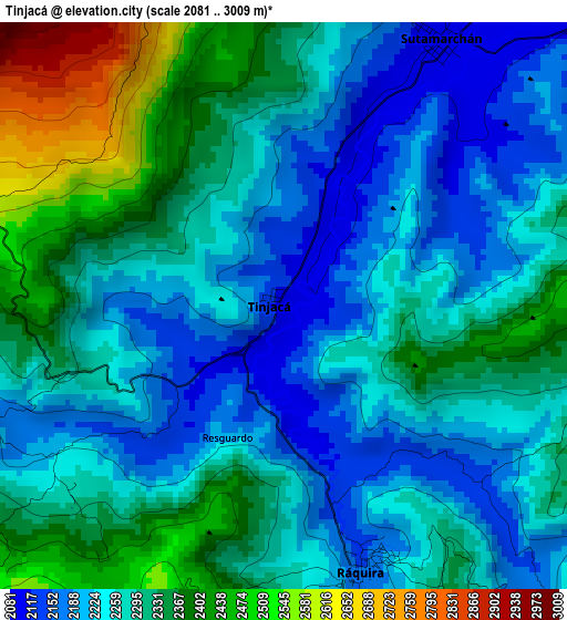
Below is the Elevation map of Tinjacá, which displays elevation range with different colors. Scale of the first map is from 2081 to 3009 m (6827 to 9872 ft) with average elevation of 2284.6 meters (=7495 ft) [note 1]
These maps also provides idea of topography and contour of this city, they are displayed at different zoom levels. More info about maps, scale and edge coordinates you can find below images.
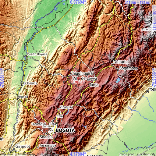
| \ | Map #1 | Topo.Map |
| Scale [m] | 2081..3009 m | × |
| Scale [ft] | 6827..9872 ft | × |
| Average | 2284.6 m = 7495 ft | × |
| Width | 9.73 km = 6 mi | 311.2 km = 193.4 mi |
| Height | 9.73 km = 6 mi | 311.2 km = 193.4 mi |
| ↑Max Latitude | 5.622896° | 6.97694° |
| Latitude at center | 5.57916° | 5.57916° |
| ↓Min Latitude | 5.535421° | 4.17804° |
| ← Min Longitude | -73.688805° | -75.05111° |
| Longitude center | -73.64486° | -73.64486° |
| →Max Longitude | -73.600915° | -72.23861° |
Nearby cities:
Cities around Tinjacá sort by population:
• Chiquinquirá elevation 2562 m
19.5 km,  282°
282°
• Villa de Leyva 2119 m
14.7 km,  65°
65°
• Samacá 2601 m
20.1 km,  118°
118°
• Ráquira 2165 m
4.8 km,  162°
162°
• Sáchica 2153 m
11.4 km,  87°
87°
• Sutamarchán 2085 m
5.1 km,  37°
37°
• Cucaita 2636 m
21.5 km,  100°
100°
• Saboyá 2640 m
19 km,  313°
313°
• Santa Sofía 2364 m
15.1 km,  17°
17°
• Chíquiza 2606 m
17.9 km,  81°
81°
• San Miguel de Sema 2605 m
10.9 km,  231°
231°
• Sora 2668 m
21.6 km, 94°
Multilingual:
 En español:
Tinjacá elevación 2106 m.
 En France:
Tinjacá élévation 2106 m.
 Auf Deutsch:
Tinjacá höhe über dem Meeresspiegel ist 2106 m.

Sources and notes:
- [note 1] Map square and city borders are not equal. Map elevation data is calculated only from area inside that square.
- [src 1] Elevation data from geonames database provided with same terms of usage.
- [src 2] The elevation map of Tinjacá is generated using elevation data from NASA's 3 arcsec (90m) resolution SRTM data.
- [src 3] Base (background) map © OpenStreetMap contributors tiles are generated by Geofabrik and OpenTopoMap.
Copyright & License:
This Tinjacá Elevation Map is licensed under CC BY-SA. You may reuse any part from this page, if you give a proper credit by linking to this URL:
 More info on terms of use page.