Samacá elevation
Samacá (Boyacá), Colombia elevation is 2601 meters and Samacá elevation in feet is 8533 ft above sea level [src 1]. Samacá is a seat of a second-order administrative division (feature code) with elevation that is 1452 meters (4764 ft) bigger than average city elevation in Colombia.
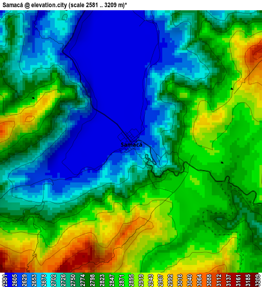
Below is the Elevation map of Samacá, which displays elevation range with different colors. Scale of the first map is from 2581 to 3209 m (8468 to 10528 ft) with average elevation of 2785.7 meters (=9139 ft) [note 1]
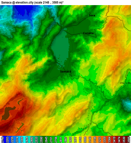
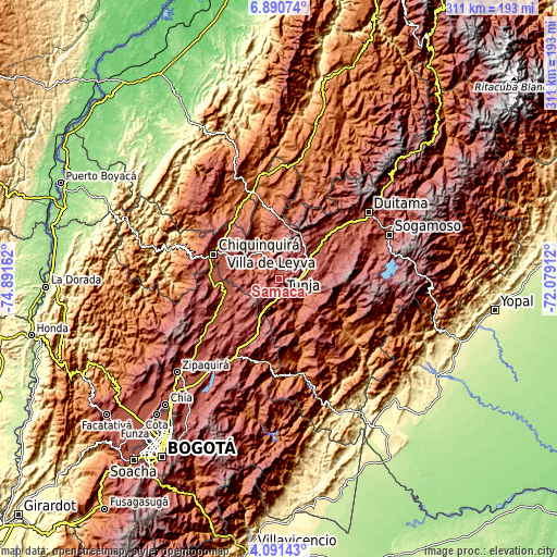
These maps also provides idea of topography and contour of this city, they are displayed at different zoom levels. More info about maps, scale and edge coordinates you can find below images.
| \ | Map #1 | Map #2 | Topo.Map |
| Scale [m] | 2581..3209 m | 2148..3585 m | × |
| Scale [ft] | 8468..10528 ft | 7047..11762 ft | × |
| Average | 2785.7 m = 9139 ft | 2862 m = 9390 ft | × |
| Width | 9.73 km = 6 mi | 19.46 km = 12.1 mi | 311.3 km = 193.4 mi |
| Height | 9.73 km = 6 mi | 19.46 km = 12.1 mi | 311.3 km = 193.4 mi |
| ↑Max Latitude | 5.536472° | 5.580211° | 6.89074° |
| Latitude at center | 5.49273° | 5.49273° | 5.49273° |
| ↓Min Latitude | 5.448985° | 5.405237° | 4.09143° |
| ← Min Longitude | -73.529315° | -73.573261° | -74.89162° |
| Longitude center | -73.48537° | -73.48537° | -73.48537° |
| →Max Longitude | -73.441425° | -73.397479° | -72.07912° |
Nearby cities:
Cities around Samacá sort by population:
• Tunja elevation 2804 m
13.8 km,  70°
70°
• Villa de Leyva 2119 m
16.3 km,  344°
344°
• Ráquira 2165 m
17 km,  287°
287°
• Sáchica 2153 m
12 km,  328°
328°
• Ventaquemada 2611 m
14.5 km,  195°
195°
• Cucaita 2636 m
6.6 km,  31°
31°
• Nuevo Colón 2457 m
15.8 km,  168°
168°
• Soracá 2802 m
16.9 km,  87°
87°
• Boyacá 2411 m
14.3 km,  107°
107°
• Chíquiza 2606 m
12.4 km,  0°
0°
• Sora 2668 m
8.9 km, 25°
• Motavita 2906 m
16.1 km,  54°
54°
Multilingual:
 En español:
Samacá elevación 2601 m.
 En France:
Samacá élévation 2601 m.


Sources and notes:
- [note 1] Map square and city borders are not equal. Map elevation data is calculated only from area inside that square.
- [src 1] Elevation data from geonames database provided with same terms of usage.
- [src 2] The elevation map of Samacá is generated using elevation data from NASA's 3 arcsec (90m) resolution SRTM data.
- [src 3] Base (background) map © OpenStreetMap contributors tiles are generated by Geofabrik and OpenTopoMap.
Copyright & License:
This Samacá Elevation Map is licensed under CC BY-SA. You may reuse any part from this page, if you give a proper credit by linking to this URL:
 More info on terms of use page.