Susa elevation
Susa (Cundinamarca), Colombia elevation is 2561 meters and Susa elevation in feet is 8402 ft above sea level [src 1]. Susa is a seat of a second-order administrative division (feature code) with elevation that is 1412 meters (4633 ft) bigger than average city elevation in Colombia.
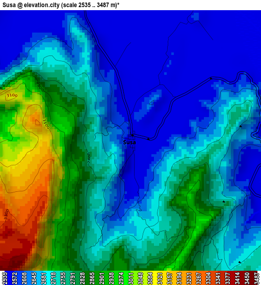
Below is the Elevation map of Susa, which displays elevation range with different colors. Scale of the first map is from 2535 to 3487 m (8317 to 11440 ft) with average elevation of 2743.3 meters (=9000 ft) [note 1]
These maps also provides idea of topography and contour of this city, they are displayed at different zoom levels. More info about maps, scale and edge coordinates you can find below images.
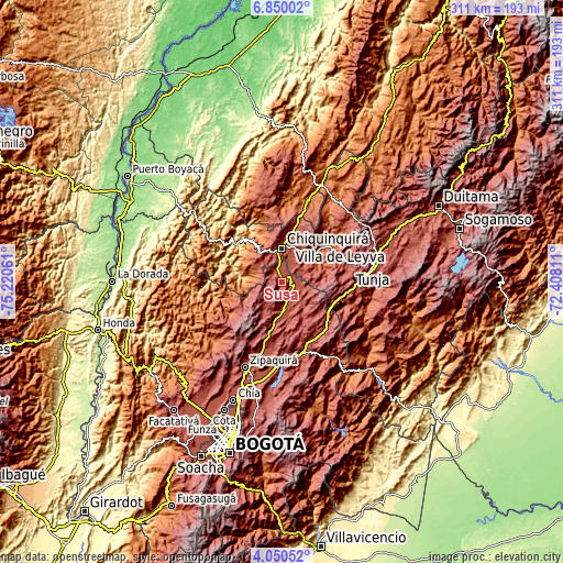
| \ | Map #1 | Topo.Map |
| Scale [m] | 2535..3487 m | × |
| Scale [ft] | 8317..11440 ft | × |
| Average | 2743.3 m = 9000 ft | × |
| Width | 9.73 km = 6 mi | 311.3 km = 193.4 mi |
| Height | 9.73 km = 6 mi | 311.3 km = 193.4 mi |
| ↑Max Latitude | 5.495645° | 6.85002° |
| Latitude at center | 5.4519° | 5.4519° |
| ↓Min Latitude | 5.408152° | 4.05052° |
| ← Min Longitude | -73.858305° | -75.22061° |
| Longitude center | -73.81436° | -73.81436° |
| →Max Longitude | -73.770415° | -72.40811° |
Nearby cities:
Cities around Susa sort by population:
• Chiquinquirá elevation 2562 m
18.3 km,  358°
358°
• Villa de San Diego de Ubaté 2561 m
15.9 km,  180°
180°
• Simijaca 2563 m
7.1 km,  323°
323°
• Guachetá 2684 m
16.1 km,  117°
117°
• Lenguazaque 2577 m
19.7 km,  144°
144°
• Ráquira 2165 m
22.3 km,  64°
64°
• Carmen de Carupa 2965 m
15 km,  220°
220°
• Cucunubá 2564 m
23.1 km,  166°
166°
• San Miguel de Sema 2605 m
12.6 km,  53°
53°
• Fúquene 2866 m
5.7 km,  159°
159°
• Caldas 2671 m
12.7 km,  333°
333°
• Buenavista 2123 m
16.4 km,  294°
294°
Multilingual:
 En español:
Susa elevación 2561 m.
 En France:
Susa élévation 2561 m.


Sources and notes:
- [note 1] Map square and city borders are not equal. Map elevation data is calculated only from area inside that square.
- [src 1] Elevation data from geonames database provided with same terms of usage.
- [src 2] The elevation map of Susa is generated using elevation data from NASA's 3 arcsec (90m) resolution SRTM data.
- [src 3] Base (background) map © OpenStreetMap contributors tiles are generated by Geofabrik and OpenTopoMap.
Copyright & License:
This Susa Elevation Map is licensed under CC BY-SA. You may reuse any part from this page, if you give a proper credit by linking to this URL:
 More info on terms of use page.