Buenavista elevation
Buenavista (Boyacá), Colombia elevation is 2123 meters and Buenavista elevation in feet is 6965 ft above sea level [src 1]. Buenavista is a seat of a second-order administrative division (feature code) with elevation that is 974 meters (3196 ft) bigger than average city elevation in Colombia.
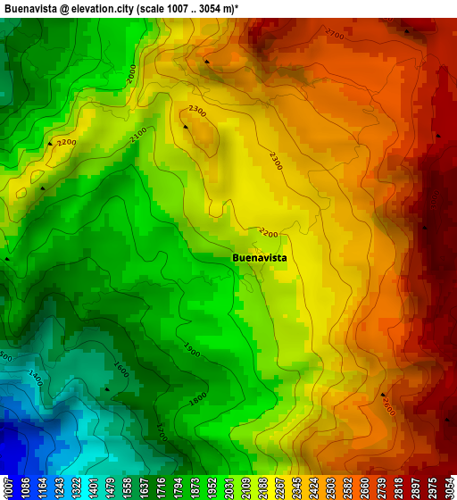
Below is the Elevation map of Buenavista, which displays elevation range with different colors. Scale of the first map is from 1007 to 3054 m (3304 to 10020 ft) with average elevation of 2170.4 meters (=7121 ft) [note 1]
These maps also provides idea of topography and contour of this city, they are displayed at different zoom levels. More info about maps, scale and edge coordinates you can find below images.
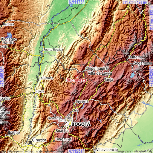
| \ | Map #1 | Topo.Map |
| Scale [m] | 1007..3054 m | × |
| Scale [ft] | 3304..10020 ft | × |
| Average | 2170.4 m = 7121 ft | × |
| Width | 9.73 km = 6 mi | 311.2 km = 193.4 mi |
| Height | 9.73 km = 6 mi | 311.3 km = 193.4 mi |
| ↑Max Latitude | 5.55751° | 6.91173° |
| Latitude at center | 5.51377° | 5.51377° |
| ↓Min Latitude | 5.470026° | 4.11251° |
| ← Min Longitude | -73.993075° | -75.35538° |
| Longitude center | -73.94913° | -73.94913° |
| →Max Longitude | -73.905185° | -72.54288° |
Nearby cities:
Cities around Buenavista sort by population:
• Chiquinquirá elevation 2562 m
18.5 km,  51°
51°
• Muzo 770 m
17.7 km,  277°
277°
• Simijaca 2563 m
10.8 km,  96°
96°
• Pauna 1080 m
16.5 km,  347°
347°
• Carmen de Carupa 2965 m
19.1 km,  164°
164°
• Susa 2561 m
16.4 km,  114°
114°
• San Pablo de Borbur 885 m
20.3 km,  318°
318°
• Maripí 1199 m
7.8 km,  302°
302°
• Coper 951 m
11.3 km,  248°
248°
• Briceño 1358 m
19.7 km,  10°
10°
• Fúquene 2866 m
20.8 km,  125°
125°
• Caldas 2671 m
10.3 km,  63°
63°
Multilingual:
 En español:
Buenavista elevación 2123 m.
 En France:
Buenavista élévation 2123 m.
 Auf Deutsch:
Buenavista höhe über dem Meeresspiegel ist 2123 m.

Sources and notes:
- [note 1] Map square and city borders are not equal. Map elevation data is calculated only from area inside that square.
- [src 1] Elevation data from geonames database provided with same terms of usage.
- [src 2] The elevation map of Buenavista is generated using elevation data from NASA's 3 arcsec (90m) resolution SRTM data.
- [src 3] Base (background) map © OpenStreetMap contributors tiles are generated by Geofabrik and OpenTopoMap.
Copyright & License:
This Buenavista Elevation Map is licensed under CC BY-SA. You may reuse any part from this page, if you give a proper credit by linking to this URL:
 More info on terms of use page.