Albania elevation
Albania (Santander), Colombia elevation is 1282 meters and Albania elevation in feet is 4206 ft above sea level [src 1]. Albania is a seat of a second-order administrative division (feature code) with elevation that is 133 meters (436 ft) bigger than average city elevation in Colombia.
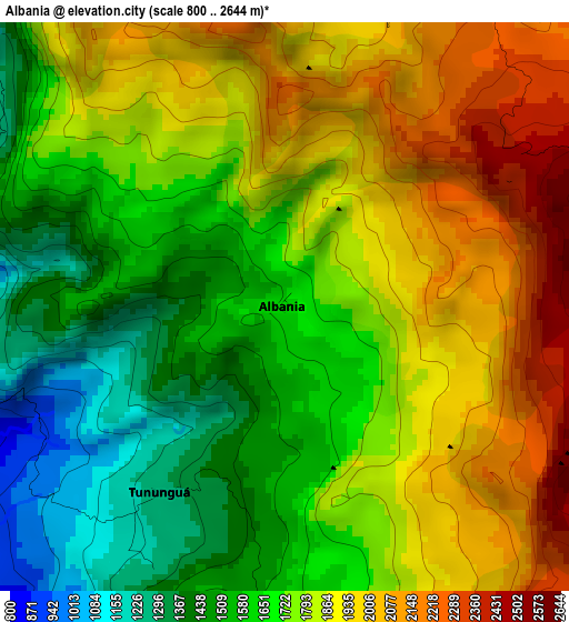
Below is the Elevation map of Albania, which displays elevation range with different colors. Scale of the first map is from 800 to 2644 m (2625 to 8675 ft) with average elevation of 1758.9 meters (=5771 ft) [note 1]
These maps also provides idea of topography and contour of this city, they are displayed at different zoom levels. More info about maps, scale and edge coordinates you can find below images.
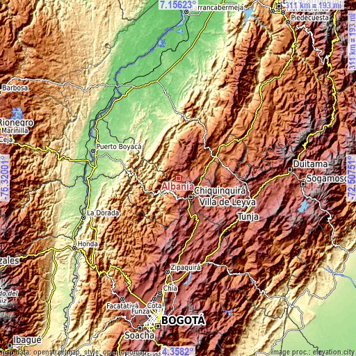
| \ | Map #1 | Topo.Map |
| Scale [m] | 800..2644 m | × |
| Scale [ft] | 2625..8675 ft | × |
| Average | 1758.9 m = 5771 ft | × |
| Width | 9.72 km = 6 mi | 311.1 km = 193.3 mi |
| Height | 9.72 km = 6 mi | 311.1 km = 193.3 mi |
| ↑Max Latitude | 5.802662° | 7.15623° |
| Latitude at center | 5.75894° | 5.75894° |
| ↓Min Latitude | 5.715215° | 4.3582° |
| ← Min Longitude | -73.957705° | -75.32001° |
| Longitude center | -73.91376° | -73.91376° |
| →Max Longitude | -73.869815° | -72.50751° |
Nearby cities:
Cities around Albania sort by population:
• Chiquinquirá elevation 2562 m
19.1 km,  146°
146°
• Pauna 1080 m
13.5 km,  214°
214°
• La Belleza 2240 m
12.8 km,  335°
335°
• San Pablo de Borbur 885 m
21 km,  235°
235°
• Saboyá 2640 m
17.4 km,  113°
113°
• Florián 1623 m
8.1 km,  309°
309°
• Maripí 1199 m
25.3 km,  204°
204°
• Sucre 2146 m
22.3 km,  37°
37°
• Jesús María 1845 m
19.7 km,  48°
48°
• Briceño 1358 m
7.9 km,  183°
183°
• Caldas 2671 m
23.3 km,  166°
166°
• Tununguá 1150 m
4.5 km,  223°
223°
Multilingual:
 En español:
Albania elevación 1282 m.
 En France:
Albania élévation 1282 m.
 Auf Deutsch:
Albania höhe über dem Meeresspiegel ist 1282 m.

Sources and notes:
- [note 1] Map square and city borders are not equal. Map elevation data is calculated only from area inside that square.
- [src 1] Elevation data from geonames database provided with same terms of usage.
- [src 2] The elevation map of Albania is generated using elevation data from NASA's 3 arcsec (90m) resolution SRTM data.
- [src 3] Base (background) map © OpenStreetMap contributors tiles are generated by Geofabrik and OpenTopoMap.
Copyright & License:
This Albania Elevation Map is licensed under CC BY-SA. You may reuse any part from this page, if you give a proper credit by linking to this URL:
 More info on terms of use page.