Gejiu elevation
Gejiu (Yunnan), China elevation is 1708 meters and Gejiu elevation in feet is 5604 ft above sea level [src 1]. Gejiu is a seat of a third-order administrative division (feature code) with elevation that is 1150 meters (3773 ft) bigger than average city elevation in China.
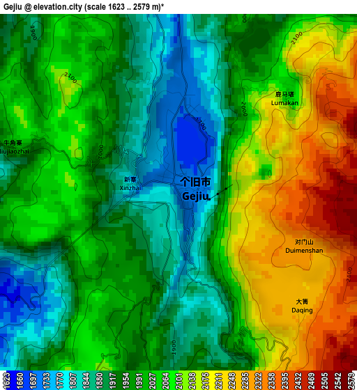
Below is the Elevation map of Gejiu, which displays elevation range with different colors. Scale of the first map is from 1623 to 2579 m (5325 to 8461 ft) with average elevation of 2024.8 meters (=6643 ft) [note 1]
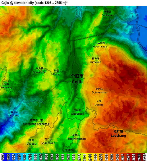
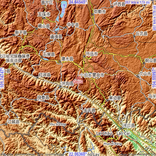
These maps also provides idea of topography and contour of this city, they are displayed at different zoom levels. More info about maps, scale and edge coordinates you can find below images.
| \ | Map #1 | Map #2 | Topo.Map |
| Scale [m] | 1623..2579 m | 1208..2755 m | × |
| Scale [ft] | 5325..8461 ft | 3963..9039 ft | × |
| Average | 2024.8 m = 6643 ft | 2024 m = 6640 ft | × |
| Width | 8.97 km = 5.6 mi | 17.94 km = 11.1 mi | 287.1 km = 178.4 mi |
| Height | 8.97 km = 5.6 mi | 17.94 km = 11.1 mi | 287.1 km = 178.4 mi |
| ↑Max Latitude | 23.401187° | 23.441511° | 24.64545° |
| Latitude at center | 23.36085° | 23.36085° | 23.36085° |
| ↓Min Latitude | 23.320501° | 23.28014° | 22.06368° |
| ← Min Longitude | 103.109775° | 103.065829° | 101.74747° |
| Longitude center | 103.15372° | 103.15372° | 103.15372° |
| →Max Longitude | 103.197665° | 103.241611° | 104.55997° |
Nearby cities:
Cities around Gejiu sort by population:
• Kaiyuan elevation 1259 m
40.5 km,  22°
22°
• Dajie 1731 m
111.8 km,  338°
338°
• Ningzhou 1620 m
95 km,  345°
345°
• Xiushan 1829 m
92.4 km,  334°
334°
• Daxing 1800 m
88 km,  240°
240°
• Yilong 1435 m
77.3 km,  298°
298°
• Yisa 721 m
72.2 km,  267°
267°
• Yuping 1261 m
71.2 km,  126°
126°
• Jinhe 1317 m
66.8 km,  171°
171°
• Lin’an 1311 m
42.5 km,  309°
309°
• Nansha 1028 m
38.4 km, 238°
• Wenlan 1309 m
28.9 km,  90°
90°
Multilingual:
 En español:
Gejiu elevación 1708 m.
 En France:
Gejiu élévation 1708 m.


Sources and notes:
- [note 1] Map square and city borders are not equal. Map elevation data is calculated only from area inside that square.
- [src 1] Elevation data from geonames database provided with same terms of usage.
- [src 2] The elevation map of Gejiu is generated using elevation data from NASA's 3 arcsec (90m) resolution SRTM data.
- [src 3] Base (background) map © OpenStreetMap contributors tiles are generated by Geofabrik and OpenTopoMap.
Copyright & License:
This Gejiu Elevation Map is licensed under CC BY-SA. You may reuse any part from this page, if you give a proper credit by linking to this URL:
 More info on terms of use page.