Daxing elevation
Daxing (Yunnan), China elevation is 1800 meters and Daxing elevation in feet is 5906 ft above sea level [src 1]. Daxing is a seat of a third-order administrative division (feature code) with elevation that is 1242 meters (4075 ft) bigger than average city elevation in China.
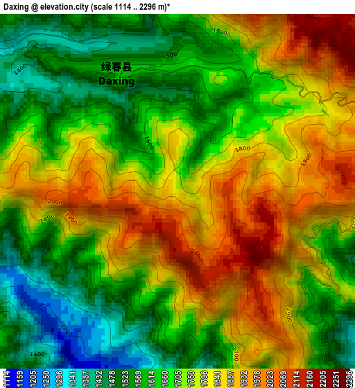
Below is the Elevation map of Daxing, which displays elevation range with different colors. Scale of the first map is from 1114 to 2296 m (3655 to 7533 ft) with average elevation of 1724.6 meters (=5658 ft) [note 1]
These maps also provides idea of topography and contour of this city, they are displayed at different zoom levels. More info about maps, scale and edge coordinates you can find below images.
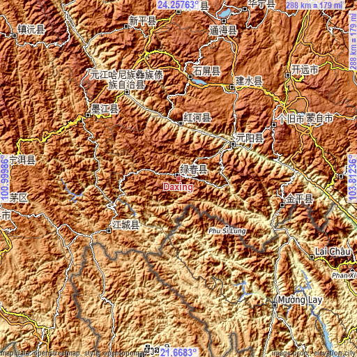
| \ | Map #1 | Topo.Map |
| Scale [m] | 1114..2296 m | × |
| Scale [ft] | 3655..7533 ft | × |
| Average | 1724.6 m = 5658 ft | × |
| Width | 9 km = 5.6 mi | 287.9 km = 178.9 mi |
| Height | 9 km = 5.6 mi | 287.9 km = 178.9 mi |
| ↑Max Latitude | 23.009615° | 24.25763° |
| Latitude at center | 22.96916° | 22.96916° |
| ↓Min Latitude | 22.928693° | 21.6683° |
| ← Min Longitude | 102.362165° | 100.99986° |
| Longitude center | 102.40611° | 102.40611° |
| →Max Longitude | 102.450055° | 103.81236° |
Nearby cities:
Cities around Daxing sort by population:
• Kaiyuan elevation 1259 m
122.3 km,  48°
48°
• Gejiu 1708 m
88 km,  60°
60°
• Guishan 1875 m
127.1 km,  341°
341°
• Wenlan 1309 m
114 km,  67°
67°
• Jinhe 1317 m
89.3 km,  104°
104°
• Lianzhu 1523 m
86.3 km,  304°
304°
• Lin’an 1311 m
82.7 km,  31°
31°
• Yilong 1435 m
80.7 km,  5°
5°
• Lijiang 408 m
78.5 km,  328°
328°
• Menglie 1202 m
71.5 km,  230°
230°
• Nansha 1028 m
49.6 km, 61°
• Yisa 721 m
40.6 km, 5°
Multilingual:
 En español:
Daxing elevación 1800 m.
 En France:
Daxing élévation 1800 m.


Sources and notes:
- [note 1] Map square and city borders are not equal. Map elevation data is calculated only from area inside that square.
- [src 1] Elevation data from geonames database provided with same terms of usage.
- [src 2] The elevation map of Daxing is generated using elevation data from NASA's 3 arcsec (90m) resolution SRTM data.
- [src 3] Base (background) map © OpenStreetMap contributors tiles are generated by Geofabrik and OpenTopoMap.
Copyright & License:
This Daxing Elevation Map is licensed under CC BY-SA. You may reuse any part from this page, if you give a proper credit by linking to this URL:
 More info on terms of use page.