Kaiyuan elevation
Kaiyuan (Yunnan), China elevation is 1259 meters and Kaiyuan elevation in feet is 4131 ft above sea level [src 1]. Kaiyuan is a populated place (feature code) with elevation that is 701 meters (2300 ft) bigger than average city elevation in China.
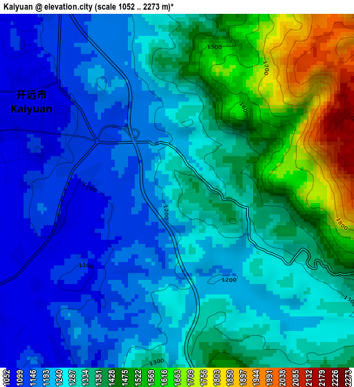
Below is the Elevation map of Kaiyuan, which displays elevation range with different colors. Scale of the first map is from 1052 to 2273 m (3451 to 7457 ft) with average elevation of 1317.7 meters (=4323 ft) [note 1]
These maps also provides idea of topography and contour of this city, they are displayed at different zoom levels. More info about maps, scale and edge coordinates you can find below images.
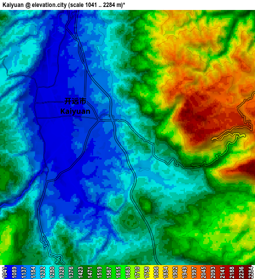
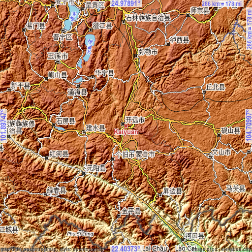
| \ | Map #1 | Map #2 | Topo.Map |
| Scale [m] | 1052..2273 m | 1041..2284 m | × |
| Scale [ft] | 3451..7457 ft | 3415..7493 ft | × |
| Average | 1317.7 m = 4323 ft | 1426.2 m = 4679 ft | × |
| Width | 8.95 km = 5.6 mi | 17.9 km = 11.1 mi | 286.3 km = 177.9 mi |
| Height | 8.95 km = 5.6 mi | 17.9 km = 11.1 mi | 286.3 km = 177.9 mi |
| ↑Max Latitude | 23.737904° | 23.778125° | 24.97891° |
| Latitude at center | 23.69767° | 23.69767° | 23.69767° |
| ↓Min Latitude | 23.657424° | 23.617166° | 22.40373° |
| ← Min Longitude | 103.259775° | 103.215829° | 101.89747° |
| Longitude center | 103.30372° | 103.30372° | 103.30372° |
| →Max Longitude | 103.347665° | 103.391611° | 104.70997° |
Nearby cities:
Cities around Kaiyuan sort by population:
• Gejiu elevation 1708 m
40.5 km,  202°
202°
• Miyang 1433 m
79.8 km,  10°
10°
• Jinping 1463 m
100.9 km,  68°
68°
• Yisa 721 m
96.3 km,  245°
245°
• Yuping 1261 m
90.3 km,  152°
152°
• Dajie 1731 m
87.1 km,  319°
319°
• Yilong 1435 m
83.2 km,  269°
269°
• Nansha 1028 m
74.9 km,  219°
219°
• Xiushan 1829 m
71.7 km,  309°
309°
• Ningzhou 1620 m
67.2 km, 324°
• Lin’an 1311 m
49.3 km,  257°
257°
• Wenlan 1309 m
39.9 km,  160°
160°
Multilingual:
 En español:
Kaiyuan elevación 1259 m.
 En France:
Kaiyuan élévation 1259 m.
 Auf Deutsch:
Kaiyuan höhe über dem Meeresspiegel ist 1259 m.

Sources and notes:
- [note 1] Map square and city borders are not equal. Map elevation data is calculated only from area inside that square.
- [src 1] Elevation data from geonames database provided with same terms of usage.
- [src 2] The elevation map of Kaiyuan is generated using elevation data from NASA's 3 arcsec (90m) resolution SRTM data.
- [src 3] Base (background) map © OpenStreetMap contributors tiles are generated by Geofabrik and OpenTopoMap.
Copyright & License:
This Kaiyuan Elevation Map is licensed under CC BY-SA. You may reuse any part from this page, if you give a proper credit by linking to this URL:
 More info on terms of use page.