Xiushan elevation
Xiushan (Yunnan), China elevation is 1829 meters and Xiushan elevation in feet is 6001 ft above sea level [src 1]. Xiushan is a seat of a third-order administrative division (feature code) with elevation that is 1271 meters (4170 ft) bigger than average city elevation in China.
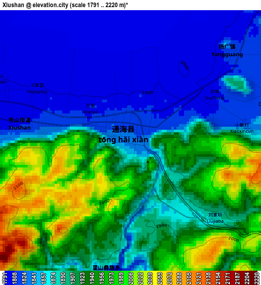
Below is the Elevation map of Xiushan, which displays elevation range with different colors. Scale of the first map is from 1791 to 2220 m (5876 to 7283 ft) with average elevation of 1892.2 meters (=6208 ft) [note 1]
These maps also provides idea of topography and contour of this city, they are displayed at different zoom levels. More info about maps, scale and edge coordinates you can find below images.
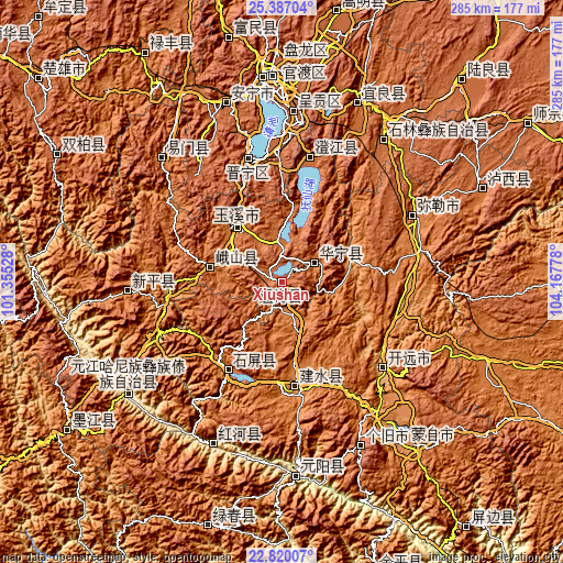
| \ | Map #1 | Topo.Map |
| Scale [m] | 1791..2220 m | × |
| Scale [ft] | 5876..7283 ft | × |
| Average | 1892.2 m = 6208 ft | × |
| Width | 8.92 km = 5.5 mi | 285.4 km = 177.3 mi |
| Height | 8.92 km = 5.5 mi | 285.4 km = 177.3 mi |
| ↑Max Latitude | 24.150095° | 25.38704° |
| Latitude at center | 24.10999° | 24.10999° |
| ↓Min Latitude | 24.069872° | 22.82007° |
| ← Min Longitude | 102.717585° | 101.35528° |
| Longitude center | 102.76153° | 102.76153° |
| →Max Longitude | 102.805475° | 104.16778° |
Nearby cities:
Cities around Xiushan sort by population:
• Kaiyuan elevation 1259 m
71.7 km,  129°
129°
• Haikou 1909 m
76.8 km,  345°
345°
• Yuxi 1638 m
35.2 km,  320°
320°
• Miyang 1433 m
76.4 km,  64°
64°
• Guishan 1875 m
77.6 km,  265°
265°
• Fenglu 1756 m
64.8 km,  13°
13°
• Kunyang 1896 m
64.3 km,  344°
344°
• Lin’an 1311 m
56.9 km,  172°
172°
• Yilong 1435 m
54.3 km,  210°
210°
• Shuangjiang 1544 m
37.3 km,  280°
280°
• Dajie 1731 m
20.7 km,  356°
356°
• Ningzhou 1620 m
18 km, 61°
Multilingual:
 En español:
Xiushan elevación 1829 m.
 En France:
Xiushan élévation 1829 m.
 Auf Deutsch:
Xiushan höhe über dem Meeresspiegel ist 1829 m.

Sources and notes:
- [note 1] Map square and city borders are not equal. Map elevation data is calculated only from area inside that square.
- [src 1] Elevation data from geonames database provided with same terms of usage.
- [src 2] The elevation map of Xiushan is generated using elevation data from NASA's 3 arcsec (90m) resolution SRTM data.
- [src 3] Base (background) map © OpenStreetMap contributors tiles are generated by Geofabrik and OpenTopoMap.
Copyright & License:
This Xiushan Elevation Map is licensed under CC BY-SA. You may reuse any part from this page, if you give a proper credit by linking to this URL:
 More info on terms of use page.