Dajie elevation
Dajie (Yunnan), China elevation is 1731 meters and Dajie elevation in feet is 5679 ft above sea level [src 1]. Dajie is a seat of a third-order administrative division (feature code) with elevation that is 1173 meters (3848 ft) bigger than average city elevation in China.
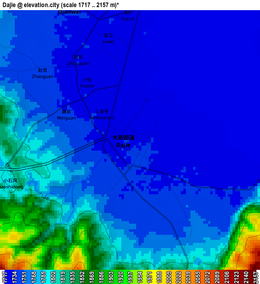
Below is the Elevation map of Dajie, which displays elevation range with different colors. Scale of the first map is from 1717 to 2157 m (5633 to 7077 ft) with average elevation of 1764.4 meters (=5789 ft) [note 1]
These maps also provides idea of topography and contour of this city, they are displayed at different zoom levels. More info about maps, scale and edge coordinates you can find below images.
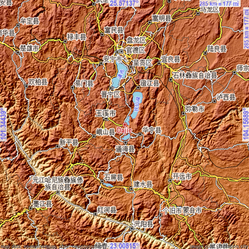
| \ | Map #1 | Topo.Map |
| Scale [m] | 1717..2157 m | × |
| Scale [ft] | 5633..7077 ft | × |
| Average | 1764.4 m = 5789 ft | × |
| Width | 8.91 km = 5.5 mi | 285 km = 177.1 mi |
| Height | 8.91 km = 5.5 mi | 285 km = 177.1 mi |
| ↑Max Latitude | 24.336277° | 25.57137° |
| Latitude at center | 24.29623° | 24.29623° |
| ↓Min Latitude | 24.256171° | 23.00815° |
| ← Min Longitude | 102.706695° | 101.34439° |
| Longitude center | 102.75064° | 102.75064° |
| →Max Longitude | 102.794585° | 104.15689° |
Nearby cities:
Cities around Dajie sort by population:
• Haikou elevation 1909 m
56.6 km,  341°
341°
• Yuxi 1638 m
22.1 km,  287°
287°
• Longquan 1591 m
72.8 km,  305°
305°
• Miyang 1433 m
71.1 km,  80°
80°
• Lufu 1681 m
73.4 km,  45°
45°
• Yilong 1435 m
72.4 km,  201°
201°
• Longcheng 1945 m
67.1 km,  4°
4°
• Fenglu 1756 m
45.3 km,  21°
21°
• Kunyang 1896 m
44.3 km, 338°
• Shuangjiang 1544 m
38.1 km,  248°
248°
• Xiushan 1829 m
20.7 km,  176°
176°
• Ningzhou 1620 m
20.7 km,  125°
125°
Multilingual:
 En español:
Dajie elevación 1731 m.
 En France:
Dajie élévation 1731 m.


Sources and notes:
- [note 1] Map square and city borders are not equal. Map elevation data is calculated only from area inside that square.
- [src 1] Elevation data from geonames database provided with same terms of usage.
- [src 2] The elevation map of Dajie is generated using elevation data from NASA's 3 arcsec (90m) resolution SRTM data.
- [src 3] Base (background) map © OpenStreetMap contributors tiles are generated by Geofabrik and OpenTopoMap.
Copyright & License:
This Dajie Elevation Map is licensed under CC BY-SA. You may reuse any part from this page, if you give a proper credit by linking to this URL:
 More info on terms of use page.