Guilin elevation
Guilin (Guangxi), China elevation is 160 meters and Guilin elevation in feet is 525 ft above sea level [src 1]. Guilin is a seat of a second-order administrative division (feature code) with elevation that is 398 meters (1306 ft) smaller than average city elevation in China.
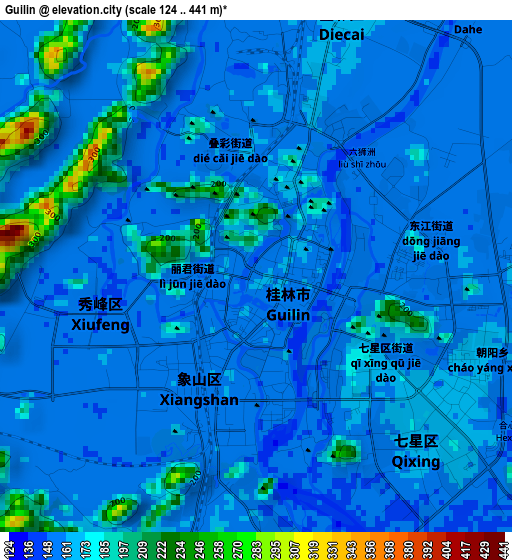
Below is the Elevation map of Guilin, which displays elevation range with different colors. Scale of the first map is from 124 to 441 m (407 to 1447 ft) with average elevation of 164.3 meters (=539 ft) [note 1]
These maps also provides idea of topography and contour of this city, they are displayed at different zoom levels. More info about maps, scale and edge coordinates you can find below images.
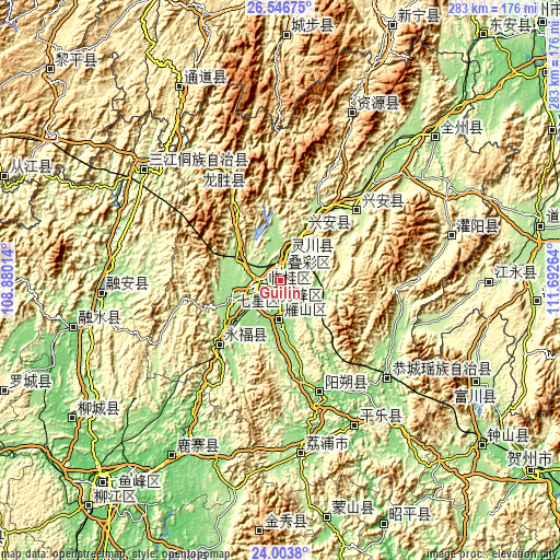
| \ | Map #1 | Map #2 | Topo.Map |
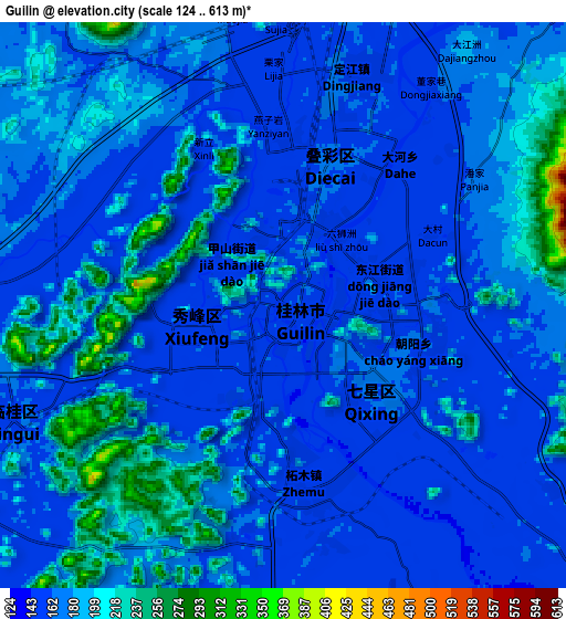
| Scale [m] | 124..441 m | 124..613 m | × |
| Scale [ft] | 407..1447 ft | 407..2011 ft | × |
| Average | 164.3 m = 539 ft | 176 m = 577 ft | × |
| Width | 8.84 km = 5.5 mi | 17.67 km = 11 mi | 282.7 km = 175.7 mi |
| Height | 8.84 km = 5.5 mi | 17.67 km = 11 mi | 282.8 km = 175.7 mi |
| ↑Max Latitude | 25.32167° | 25.361386° | 26.54675° |
| Latitude at center | 25.28194° | 25.28194° | 25.28194° |
| ↓Min Latitude | 25.242197° | 25.202442° | 24.0038° |
| ← Min Longitude | 110.242445° | 110.198499° | 108.88014° |
| Longitude center | 110.28639° | 110.28639° | 110.28639° |
| →Max Longitude | 110.330335° | 110.374281° | 111.69264° |
Nearby cities:
Cities around Guilin sort by population:
• Yangshuo elevation 116 m
59.4 km,  159°
159°
• Dazhai 862 m
60.3 km,  346°
346°
• Rong’an 122 m
91 km,  266°
266°
• Guanyang 259 m
88.5 km,  74°
74°
• Guyi 160 m
88.2 km,  308°
308°
• Licheng 170 m
86.8 km,  173°
173°
• Pingle 102 m
79.4 km,  153°
153°
• Gongcheng 133 m
73.1 km,  133°
133°
• Longsheng 357 m
63.3 km,  333°
333°
• Xing’an 312 m
51.8 km,  43°
43°
• Yongfu 205 m
43.5 km,  224°
224°
• Lingchuan 167 m
14.6 km,  14°
14°
Multilingual:
 En español:
Guilin elevación 160 m.
 En France:
Guilin élévation 160 m.


Sources and notes:
- [note 1] Map square and city borders are not equal. Map elevation data is calculated only from area inside that square.
- [src 1] Elevation data from geonames database provided with same terms of usage.
- [src 2] The elevation map of Guilin is generated using elevation data from NASA's 3 arcsec (90m) resolution SRTM data.
- [src 3] Base (background) map © OpenStreetMap contributors tiles are generated by Geofabrik and OpenTopoMap.
Copyright & License:
This Guilin Elevation Map is licensed under CC BY-SA. You may reuse any part from this page, if you give a proper credit by linking to this URL:
 More info on terms of use page.