Longsheng elevation
Longsheng (Guangxi), China elevation is 357 meters and Longsheng elevation in feet is 1171 ft above sea level [src 1]. Longsheng is a seat of a third-order administrative division (feature code) with elevation that is 201 meters (659 ft) smaller than average city elevation in China.
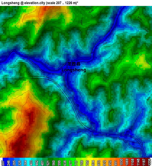
Below is the Elevation map of Longsheng, which displays elevation range with different colors. Scale of the first map is from 207 to 1226 m (679 to 4022 ft) with average elevation of 518.5 meters (=1701 ft) [note 1]
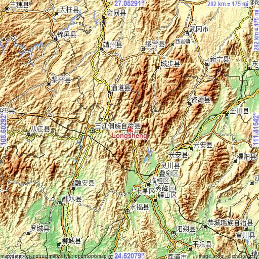
These maps also provides idea of topography and contour of this city, they are displayed at different zoom levels. More info about maps, scale and edge coordinates you can find below images.
| \ | Map #1 | Topo.Map |
| Scale [m] | 207..1226 m | × |
| Scale [ft] | 679..4022 ft | × |
| Average | 518.5 m = 1701 ft | × |
| Width | 8.8 km = 5.5 mi | 281.5 km = 174.9 mi |
| Height | 8.8 km = 5.5 mi | 281.6 km = 175 mi |
| ↑Max Latitude | 25.83317° | 27.05291° |
| Latitude at center | 25.79361° | 25.79361° |
| ↓Min Latitude | 25.754036° | 24.52079° |
| ← Min Longitude | 109.965225° | 108.60292° |
| Longitude center | 110.00917° | 110.00917° |
| →Max Longitude | 110.053115° | 111.41542° |
Nearby cities:
Cities around Longsheng sort by population:
• Guilin elevation 160 m
63.3 km,  153°
153°
• Shuangjiang 525 m
49.8 km,  323°
323°
• Xianxi 334 m
70.4 km,  328°
328°
• Linkou 396 m
52.6 km,  343°
343°
• Dazhai 862 m
14.2 km,  82°
82°
• Boyang 388 m
67.4 km,  313°
313°
• Yatunpu 413 m
55.5 km, 316°
• Ziyuan 427 m
68.7 km,  66°
66°
• Rulin 637 m
66.7 km,  22°
22°
• Xing’an 312 m
66.3 km,  106°
106°
• Lingchuan 167 m
53 km,  143°
143°
• Guyi 160 m
41 km,  267°
267°
Multilingual:
 En español:
Longsheng elevación 357 m.
 En France:
Longsheng élévation 357 m.
 Auf Deutsch:
Longsheng höhe über dem Meeresspiegel ist 357 m.

Sources and notes:
- [note 1] Map square and city borders are not equal. Map elevation data is calculated only from area inside that square.
- [src 1] Elevation data from geonames database provided with same terms of usage.
- [src 2] The elevation map of Longsheng is generated using elevation data from NASA's 3 arcsec (90m) resolution SRTM data.
- [src 3] Base (background) map © OpenStreetMap contributors tiles are generated by Geofabrik and OpenTopoMap.
Copyright & License:
This Longsheng Elevation Map is licensed under CC BY-SA. You may reuse any part from this page, if you give a proper credit by linking to this URL:
 More info on terms of use page.