Linkou elevation
Linkou (Hunan), China elevation is 396 meters and Linkou elevation in feet is 1299 ft above sea level [src 1]. Linkou is a populated place (feature code) with elevation that is 162 meters (531 ft) smaller than average city elevation in China.
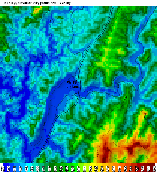
Below is the Elevation map of Linkou, which displays elevation range with different colors. Scale of the first map is from 359 to 775 m (1178 to 2543 ft) with average elevation of 462.3 meters (=1517 ft) [note 1]
These maps also provides idea of topography and contour of this city, they are displayed at different zoom levels. More info about maps, scale and edge coordinates you can find below images.
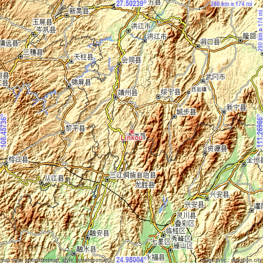
| \ | Map #1 | Topo.Map |
| Scale [m] | 359..775 m | × |
| Scale [ft] | 1178..2543 ft | × |
| Average | 462.3 m = 1517 ft | × |
| Width | 8.76 km = 5.4 mi | 280.5 km = 174.3 mi |
| Height | 8.76 km = 5.4 mi | 280.5 km = 174.3 mi |
| ↑Max Latitude | 26.287467° | 27.50239° |
| Latitude at center | 26.24806° | 26.24806° |
| ↓Min Latitude | 26.208639° | 24.98004° |
| ← Min Longitude | 109.819665° | 108.45736° |
| Longitude center | 109.86361° | 109.86361° |
| →Max Longitude | 109.907555° | 111.26986° |
Nearby cities:
Cities around Linkou sort by population:
• Shuangjiang elevation 525 m
18.2 km,  235°
235°
• Zhaishi Miaozu Dongzuxiang 442 m
33.4 km,  32°
32°
• Xianxi 334 m
24 km,  293°
293°
• Pukou 432 m
43.2 km,  314°
314°
• Boyang 388 m
34.5 km,  263°
263°
• Dongshan Dongzuxiang 427 m
38.7 km,  4°
4°
• Yatunpu 413 m
25.8 km,  246°
246°
• Zhuzhoujiang Miaozuxiang 351 m
51.8 km,  23°
23°
• Hongzhou 378 m
47.4 km, 253°
• Changpu 462 m
43.8 km, 33°
• Quyang 440 m
42.7 km,  328°
328°
• Rulin 637 m
41.6 km,  74°
74°
Multilingual:
 En español:
Linkou elevación 396 m.
 En France:
Linkou élévation 396 m.


Sources and notes:
- [note 1] Map square and city borders are not equal. Map elevation data is calculated only from area inside that square.
- [src 1] Elevation data from geonames database provided with same terms of usage.
- [src 2] The elevation map of Linkou is generated using elevation data from NASA's 3 arcsec (90m) resolution SRTM data.
- [src 3] Base (background) map © OpenStreetMap contributors tiles are generated by Geofabrik and OpenTopoMap.
Copyright & License:
This Linkou Elevation Map is licensed under CC BY-SA. You may reuse any part from this page, if you give a proper credit by linking to this URL:
 More info on terms of use page.