Yangshuo elevation
Yangshuo (Guangxi), China elevation is 116 meters and Yangshuo elevation in feet is 381 ft above sea level [src 1]. Yangshuo is a populated place(s) (feature code) with elevation that is 442 meters (1450 ft) smaller than average city elevation in China.
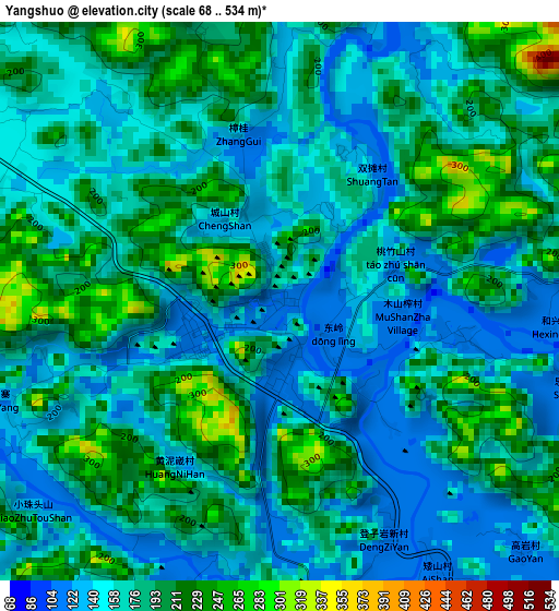
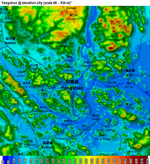
Below is the Elevation map of Yangshuo, which displays elevation range with different colors. Scale of the first map is from 68 to 534 m (223 to 1752 ft) with average elevation of 174.4 meters (=572 ft) [note 1]
These maps also provides idea of topography and contour of this city, they are displayed at different zoom levels. More info about maps, scale and edge coordinates you can find below images.
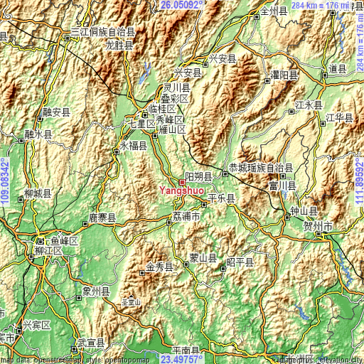
| \ | Map #1 | Map #2 | Topo.Map |
| Scale [m] | 68..534 m | 68..534 m | × |
| Scale [ft] | 223..1752 ft | 223..1752 ft | × |
| Average | 174.4 m = 572 ft | 192.2 m = 631 ft | × |
| Width | 8.87 km = 5.5 mi | 17.75 km = 11 mi | 283.9 km = 176.4 mi |
| Height | 8.87 km = 5.5 mi | 17.75 km = 11 mi | 283.9 km = 176.4 mi |
| ↑Max Latitude | 24.820702° | 24.860582° | 26.05092° |
| Latitude at center | 24.78081° | 24.78081° | 24.78081° |
| ↓Min Latitude | 24.740905° | 24.700987° | 23.49757° |
| ← Min Longitude | 110.445725° | 110.401779° | 109.08342° |
| Longitude center | 110.48967° | 110.48967° | 110.48967° |
| →Max Longitude | 110.533615° | 110.577561° | 111.89592° |
Nearby cities:
Cities around Yangshuo sort by population:
• Guilin elevation 160 m
59.4 km,  339°
339°
• Zhongshan 139 m
86.4 km,  108°
108°
• Luzhai 94 m
82.7 km,  247°
247°
• Jinxiu 908 m
78.1 km,  203°
203°
• Fuyang 222 m
77.8 km,  85°
85°
• Zhaoping 112 m
74 km,  156°
156°
• Lingchuan 167 m
71.9 km,  346°
346°
• Mengshan 157 m
63.1 km,  177°
177°
• Yongfu 205 m
56.9 km,  295°
295°
• Gongcheng 133 m
33.5 km,  79°
79°
• Licheng 170 m
32.1 km, 198°
• Pingle 102 m
21.6 km,  134°
134°
Multilingual:
 En español:
Yangshuo elevación 116 m.
 En France:
Yangshuo élévation 116 m.
 Auf Deutsch:
Yangshuo höhe über dem Meeresspiegel ist 116 m.

Sources and notes:
- [note 1] Map square and city borders are not equal. Map elevation data is calculated only from area inside that square.
- [src 1] Elevation data from geonames database provided with same terms of usage.
- [src 2] The elevation map of Yangshuo is generated using elevation data from NASA's 3 arcsec (90m) resolution SRTM data.
- [src 3] Base (background) map © OpenStreetMap contributors tiles are generated by Geofabrik and OpenTopoMap.
Copyright & License:
This Yangshuo Elevation Map is licensed under CC BY-SA. You may reuse any part from this page, if you give a proper credit by linking to this URL:
 More info on terms of use page.