Rong’an elevation
Rong’an (Guangxi), China elevation is 122 meters and Rong’an elevation in feet is 400 ft above sea level [src 1]. Rong’an is a seat of a third-order administrative division (feature code) with elevation that is 436 meters (1430 ft) smaller than average city elevation in China.
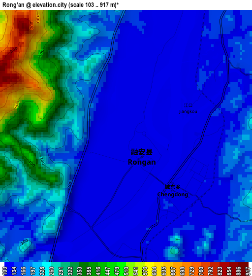
Below is the Elevation map of Rong’an, which displays elevation range with different colors. Scale of the first map is from 103 to 917 m (338 to 3009 ft) with average elevation of 203.7 meters (=668 ft) [note 1]
These maps also provides idea of topography and contour of this city, they are displayed at different zoom levels. More info about maps, scale and edge coordinates you can find below images.
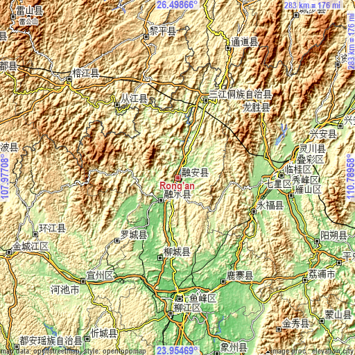
| \ | Map #1 | Topo.Map |
| Scale [m] | 103..917 m | × |
| Scale [ft] | 338..3009 ft | × |
| Average | 203.7 m = 668 ft | × |
| Width | 8.84 km = 5.5 mi | 282.9 km = 175.8 mi |
| Height | 8.84 km = 5.5 mi | 282.9 km = 175.8 mi |
| ↑Max Latitude | 25.273076° | 26.49866° |
| Latitude at center | 25.23333° | 25.23333° |
| ↓Min Latitude | 25.193571° | 23.95469° |
| ← Min Longitude | 109.339385° | 107.97708° |
| Longitude center | 109.38333° | 109.38333° |
| →Max Longitude | 109.427275° | 110.78958° |
Nearby cities:
Cities around Rong’an sort by population:
• Dundong elevation 499 m
89.9 km,  344°
344°
• Gaozeng 254 m
77.4 km,  324°
324°
• Xishan 229 m
65.6 km, 320°
• Gaowu 787 m
60.2 km,  307°
307°
• Darong 215 m
80.5 km, 319°
• Luzhai 94 m
89.1 km,  156°
156°
• Longsheng 357 m
88.5 km,  45°
45°
• Dongmen 348 m
69.1 km,  224°
224°
• Yongfu 205 m
65.4 km,  112°
112°
• Dabu 100 m
64.7 km,  193°
193°
• Guyi 160 m
64.3 km,  19°
19°
• Rongshui 114 m
22.9 km, 215°
Multilingual:
 En español:
Rong’an elevación 122 m.
 En France:
Rong’an élévation 122 m.


Sources and notes:
- [note 1] Map square and city borders are not equal. Map elevation data is calculated only from area inside that square.
- [src 1] Elevation data from geonames database provided with same terms of usage.
- [src 2] The elevation map of Rong’an is generated using elevation data from NASA's 3 arcsec (90m) resolution SRTM data.
- [src 3] Base (background) map © OpenStreetMap contributors tiles are generated by Geofabrik and OpenTopoMap.
Copyright & License:
This Rong’an Elevation Map is licensed under CC BY-SA. You may reuse any part from this page, if you give a proper credit by linking to this URL:
 More info on terms of use page.