Guanyang elevation
Guanyang (Guangxi), China elevation is 259 meters and Guanyang elevation in feet is 850 ft above sea level [src 1]. Guanyang is a seat of a third-order administrative division (feature code) with elevation that is 299 meters (981 ft) smaller than average city elevation in China.
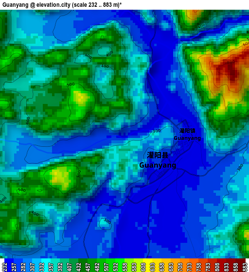
Below is the Elevation map of Guanyang, which displays elevation range with different colors. Scale of the first map is from 232 to 883 m (761 to 2897 ft) with average elevation of 359.4 meters (=1179 ft) [note 1]
These maps also provides idea of topography and contour of this city, they are displayed at different zoom levels. More info about maps, scale and edge coordinates you can find below images.
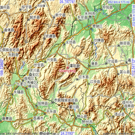
| \ | Map #1 | Topo.Map |
| Scale [m] | 232..883 m | × |
| Scale [ft] | 761..2897 ft | × |
| Average | 359.4 m = 1179 ft | × |
| Width | 8.82 km = 5.5 mi | 282.3 km = 175.4 mi |
| Height | 8.82 km = 5.5 mi | 282.3 km = 175.4 mi |
| ↑Max Latitude | 25.534889° | 26.75776° |
| Latitude at center | 25.49523° | 25.49523° |
| ↓Min Latitude | 25.455557° | 24.2193° |
| ← Min Longitude | 111.090925° | 109.72862° |
| Longitude center | 111.13487° | 111.13487° |
| →Max Longitude | 111.178815° | 112.54112° |
Nearby cities:
Cities around Guanyang sort by population:
• Guilin elevation 160 m
88.5 km,  254°
254°
• Lingchuan 167 m
82.1 km,  263°
263°
• Shunling 196 m
80.5 km,  82°
82°
• Gongcheng 133 m
80.3 km,  203°
203°
• Ziyuan 427 m
77.9 km,  320°
320°
• Fuyang 222 m
74.5 km,  170°
170°
• Longbo 557 m
68.6 km,  45°
45°
• Tuojiang 230 m
55.7 km,  128°
128°
• Xing’an 312 m
51.3 km,  285°
285°
• Quanzhou 152 m
50.9 km,  348°
348°
• Daojiang 182 m
41.8 km,  89°
89°
• Xiaopu 268 m
33.8 km,  147°
147°
Multilingual:
 En español:
Guanyang elevación 259 m.
 En France:
Guanyang élévation 259 m.
 Auf Deutsch:
Guanyang höhe über dem Meeresspiegel ist 259 m.

Sources and notes:
- [note 1] Map square and city borders are not equal. Map elevation data is calculated only from area inside that square.
- [src 1] Elevation data from geonames database provided with same terms of usage.
- [src 2] The elevation map of Guanyang is generated using elevation data from NASA's 3 arcsec (90m) resolution SRTM data.
- [src 3] Base (background) map © OpenStreetMap contributors tiles are generated by Geofabrik and OpenTopoMap.
Copyright & License:
This Guanyang Elevation Map is licensed under CC BY-SA. You may reuse any part from this page, if you give a proper credit by linking to this URL:
 More info on terms of use page.