Quanzhou elevation
Quanzhou (Guangxi), China elevation is 152 meters and Quanzhou elevation in feet is 499 ft above sea level [src 1]. Quanzhou is a seat of a third-order administrative division (feature code) with elevation that is 406 meters (1332 ft) smaller than average city elevation in China.
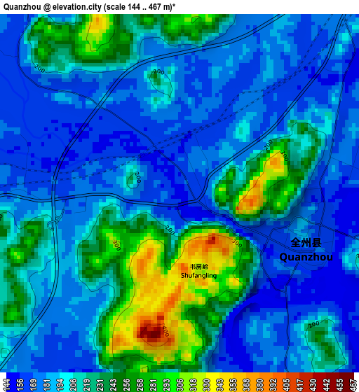
Below is the Elevation map of Quanzhou, which displays elevation range with different colors. Scale of the first map is from 144 to 467 m (472 to 1532 ft) with average elevation of 204.4 meters (=671 ft) [note 1]
These maps also provides idea of topography and contour of this city, they are displayed at different zoom levels. More info about maps, scale and edge coordinates you can find below images.
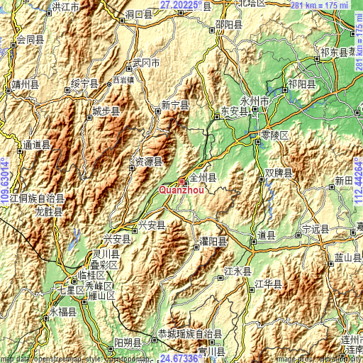
| \ | Map #1 | Topo.Map |
| Scale [m] | 144..467 m | × |
| Scale [ft] | 472..1532 ft | × |
| Average | 204.4 m = 671 ft | × |
| Width | 8.79 km = 5.5 mi | 281.2 km = 174.7 mi |
| Height | 8.79 km = 5.5 mi | 281.2 km = 174.7 mi |
| ↑Max Latitude | 25.9841° | 27.20225° |
| Latitude at center | 25.94459° | 25.94459° |
| ↓Min Latitude | 25.905067° | 24.67336° |
| ← Min Longitude | 110.992445° | 109.63014° |
| Longitude center | 111.03639° | 111.03639° |
| →Max Longitude | 111.080335° | 112.44264° |
Nearby cities:
Cities around Quanzhou sort by population:
• Baisha elevation 296 m
65.1 km,  350°
350°
• Malin 846 m
69.1 km,  325°
325°
• Huanglong 315 m
67.1 km, 351°
• Yaoshi 318 m
45.9 km, 327°
• Qingjiangqiao 323 m
73.5 km,  356°
356°
• Daojiang 182 m
71.8 km,  134°
134°
• Longbo 557 m
58.6 km,  91°
91°
• Jinshi 343 m
57.7 km,  335°
335°
• Baiyashi 167 m
54.3 km,  24°
24°
• Xing’an 312 m
53.5 km,  227°
227°
• Guanyang 259 m
50.9 km,  168°
168°
• Ziyuan 427 m
40.9 km,  284°
284°
Multilingual:
 En español:
Quanzhou elevación 152 m.
 En France:
Quanzhou élévation 152 m.
 Auf Deutsch:
Quanzhou höhe über dem Meeresspiegel ist 152 m.

Sources and notes:
- [note 1] Map square and city borders are not equal. Map elevation data is calculated only from area inside that square.
- [src 1] Elevation data from geonames database provided with same terms of usage.
- [src 2] The elevation map of Quanzhou is generated using elevation data from NASA's 3 arcsec (90m) resolution SRTM data.
- [src 3] Base (background) map © OpenStreetMap contributors tiles are generated by Geofabrik and OpenTopoMap.
Copyright & License:
This Quanzhou Elevation Map is licensed under CC BY-SA. You may reuse any part from this page, if you give a proper credit by linking to this URL:
 More info on terms of use page.