Shuangjiang elevation
Shuangjiang (Chongqing), China elevation is 224 meters and Shuangjiang elevation in feet is 735 ft above sea level [src 1]. Shuangjiang is a seat of a third-order administrative division (feature code) with elevation that is 334 meters (1096 ft) smaller than average city elevation in China.
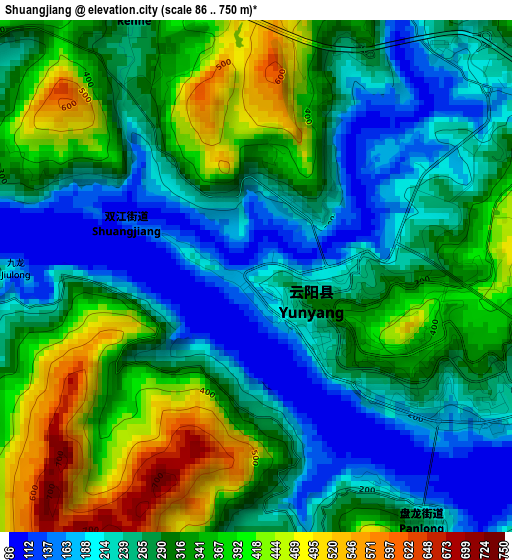
Below is the Elevation map of Shuangjiang, which displays elevation range with different colors. Scale of the first map is from 86 to 750 m (282 to 2461 ft) with average elevation of 299 meters (=981 ft) [note 1]
These maps also provides idea of topography and contour of this city, they are displayed at different zoom levels. More info about maps, scale and edge coordinates you can find below images.
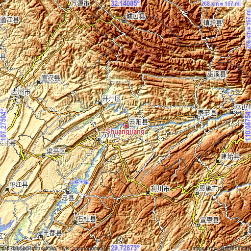
| \ | Map #1 | Topo.Map |
| Scale [m] | 86..750 m | × |
| Scale [ft] | 282..2461 ft | × |
| Average | 299 m = 981 ft | × |
| Width | 8.38 km = 5.2 mi | 268.2 km = 166.7 mi |
| Height | 8.38 km = 5.2 mi | 268.2 km = 166.7 mi |
| ↑Max Latitude | 30.980084° | 32.14085° |
| Latitude at center | 30.9424° | 30.9424° |
| ↓Min Latitude | 30.904701° | 29.72873° |
| ← Min Longitude | 108.637345° | 107.27504° |
| Longitude center | 108.68129° | 108.68129° |
| →Max Longitude | 108.725235° | 110.08754° |
Nearby cities:
Cities around Shuangjiang sort by population:
• Wanxian elevation 257 m
32.8 km,  244°
244°
• Enshi 451 m
104.8 km,  132°
132°
• Lichuan 1255 m
73.2 km,  167°
167°
• Gecheng 761 m
111.9 km,  359°
359°
• Yezhou 557 m
106.4 km,  110°
110°
• Xiaoduchuan 427 m
105 km, 133°
• Chengxiang 215 m
102.9 km,  60°
60°
• Zhongzhou 230 m
95.1 km,  220°
220°
• Xinning 462 m
79.4 km,  281°
281°
• Yong’an 345 m
74.6 km,  83°
83°
• Hanfeng 182 m
36.6 km,  313°
313°
• Chenjiaba 252 m
32.7 km, 244°
Multilingual:
 En español:
Shuangjiang elevación 224 m.
 En France:
Shuangjiang élévation 224 m.
 Auf Deutsch:
Shuangjiang höhe über dem Meeresspiegel ist 224 m.

Sources and notes:
- [note 1] Map square and city borders are not equal. Map elevation data is calculated only from area inside that square.
- [src 1] Elevation data from geonames database provided with same terms of usage.
- [src 2] The elevation map of Shuangjiang is generated using elevation data from NASA's 3 arcsec (90m) resolution SRTM data.
- [src 3] Base (background) map © OpenStreetMap contributors tiles are generated by Geofabrik and OpenTopoMap.
Copyright & License:
This Shuangjiang Elevation Map is licensed under CC BY-SA. You may reuse any part from this page, if you give a proper credit by linking to this URL:
 More info on terms of use page.