Gecheng elevation
Gecheng (Chongqing), China elevation is 761 meters and Gecheng elevation in feet is 2497 ft above sea level [src 1]. Gecheng is a seat of a third-order administrative division (feature code) with elevation that is 203 meters (666 ft) bigger than average city elevation in China.
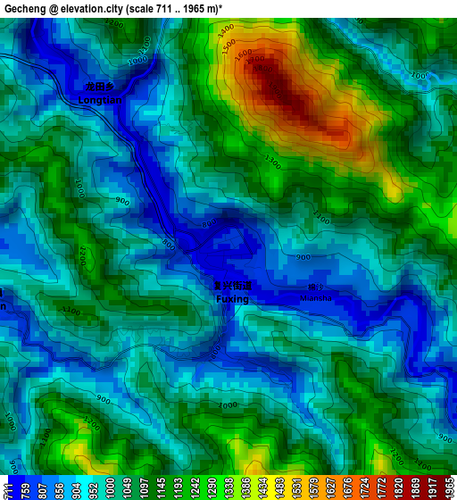
Below is the Elevation map of Gecheng, which displays elevation range with different colors. Scale of the first map is from 711 to 1965 m (2333 to 6447 ft) with average elevation of 1043.1 meters (=3422 ft) [note 1]
These maps also provides idea of topography and contour of this city, they are displayed at different zoom levels. More info about maps, scale and edge coordinates you can find below images.
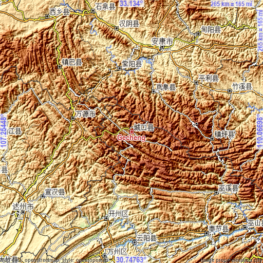
| \ | Map #1 | Topo.Map |
| Scale [m] | 711..1965 m | × |
| Scale [ft] | 2333..6447 ft | × |
| Average | 1043.1 m = 3422 ft | × |
| Width | 8.29 km = 5.2 mi | 265.3 km = 164.8 mi |
| Height | 8.29 km = 5.2 mi | 265.3 km = 164.8 mi |
| ↑Max Latitude | 31.985841° | 33.134° |
| Latitude at center | 31.94856° | 31.94856° |
| ↓Min Latitude | 31.911264° | 30.74763° |
| ← Min Longitude | 108.616785° | 107.25448° |
| Longitude center | 108.66073° | 108.66073° |
| →Max Longitude | 108.704675° | 110.06698° |
Nearby cities:
Cities around Gecheng sort by population:
• Ankang elevation 273 m
88 km,  22°
22°
• Yong’an 345 m
128 km,  143°
143°
• Xinning 462 m
122.1 km,  218°
218°
• Shuangjiang 224 m
111.9 km,  179°
179°
• Chengxiang 215 m
109.7 km,  123°
123°
• Zhuxi Chengguanzhen 450 m
108.5 km,  67°
67°
• Hanbin 694 m
107.1 km,  12°
12°
• Hanyin Chengguanzhen 361 m
105.9 km,  352°
352°
• Jingyang 963 m
96.6 km,  310°
310°
• Hanfeng 182 m
90 km,  195°
195°
• Ziyang Chengguanzhen 324 m
64.6 km, 349°
• Langao Chengguanzhen 823 m
44.8 km,  29°
29°
Multilingual:
 En español:
Gecheng elevación 761 m.
 En France:
Gecheng élévation 761 m.


Sources and notes:
- [note 1] Map square and city borders are not equal. Map elevation data is calculated only from area inside that square.
- [src 1] Elevation data from geonames database provided with same terms of usage.
- [src 2] The elevation map of Gecheng is generated using elevation data from NASA's 3 arcsec (90m) resolution SRTM data.
- [src 3] Base (background) map © OpenStreetMap contributors tiles are generated by Geofabrik and OpenTopoMap.
Copyright & License:
This Gecheng Elevation Map is licensed under CC BY-SA. You may reuse any part from this page, if you give a proper credit by linking to this URL:
 More info on terms of use page.