Chengxiang elevation
Chengxiang (Chongqing), China elevation is 215 meters and Chengxiang elevation in feet is 705 ft above sea level [src 1]. Chengxiang is a seat of a third-order administrative division (feature code) with elevation that is 343 meters (1125 ft) smaller than average city elevation in China.
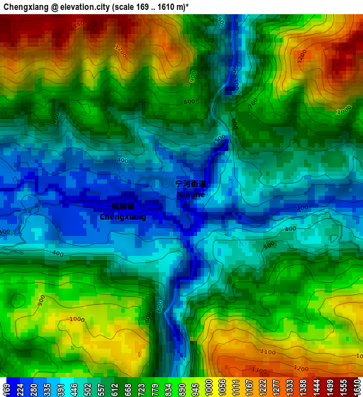
Below is the Elevation map of Chengxiang, which displays elevation range with different colors. Scale of the first map is from 169 to 1610 m (554 to 5282 ft) with average elevation of 700.4 meters (=2298 ft) [note 1]
These maps also provides idea of topography and contour of this city, they are displayed at different zoom levels. More info about maps, scale and edge coordinates you can find below images.
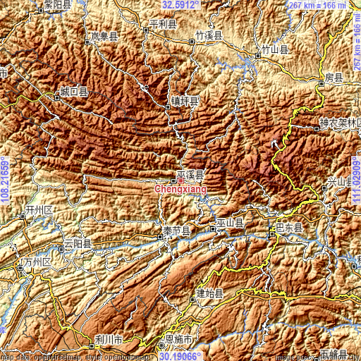
| \ | Map #1 | Topo.Map |
| Scale [m] | 169..1610 m | × |
| Scale [ft] | 554..5282 ft | × |
| Average | 700.4 m = 2298 ft | × |
| Width | 8.34 km = 5.2 mi | 266.9 km = 165.8 mi |
| Height | 8.34 km = 5.2 mi | 266.9 km = 165.8 mi |
| ↑Max Latitude | 31.436103° | 32.5912° |
| Latitude at center | 31.3986° | 31.3986° |
| ↓Min Latitude | 31.361082° | 30.19066° |
| ← Min Longitude | 109.578895° | 108.21659° |
| Longitude center | 109.62284° | 109.62284° |
| →Max Longitude | 109.666785° | 111.02909° |
Nearby cities:
Cities around Chengxiang sort by population:
• Langao Chengguanzhen elevation 823 m
121.7 km,  325°
325°
• Hanfeng 182 m
118.7 km,  257°
257°
• Gecheng 761 m
109.7 km,  303°
303°
• Zhushan Chengguanzhen 259 m
108.3 km,  32°
32°
• Songbai 1166 m
107.1 km,  68°
68°
• Gufu 918 m
105.1 km,  92°
92°
• Zhuxi Chengguanzhen 450 m
103.5 km,  5°
5°
• Shuangjiang 224 m
102.9 km,  240°
240°
• Yezhou 557 m
88.9 km,  173°
173°
• Xinling 597 m
78.1 km,  122°
122°
• Yong’an 345 m
44.8 km,  200°
200°
• Wushan 351 m
42.8 km,  145°
145°
Multilingual:
 En español:
Chengxiang elevación 215 m.
 En France:
Chengxiang élévation 215 m.
 Auf Deutsch:
Chengxiang höhe über dem Meeresspiegel ist 215 m.

Sources and notes:
- [note 1] Map square and city borders are not equal. Map elevation data is calculated only from area inside that square.
- [src 1] Elevation data from geonames database provided with same terms of usage.
- [src 2] The elevation map of Chengxiang is generated using elevation data from NASA's 3 arcsec (90m) resolution SRTM data.
- [src 3] Base (background) map © OpenStreetMap contributors tiles are generated by Geofabrik and OpenTopoMap.
Copyright & License:
This Chengxiang Elevation Map is licensed under CC BY-SA. You may reuse any part from this page, if you give a proper credit by linking to this URL:
 More info on terms of use page.