Songbai elevation
Songbai (Hubei), China elevation is 1166 meters and Songbai elevation in feet is 3825 ft above sea level [src 1]. Songbai is a seat of a third-order administrative division (feature code) with elevation that is 608 meters (1995 ft) bigger than average city elevation in China.
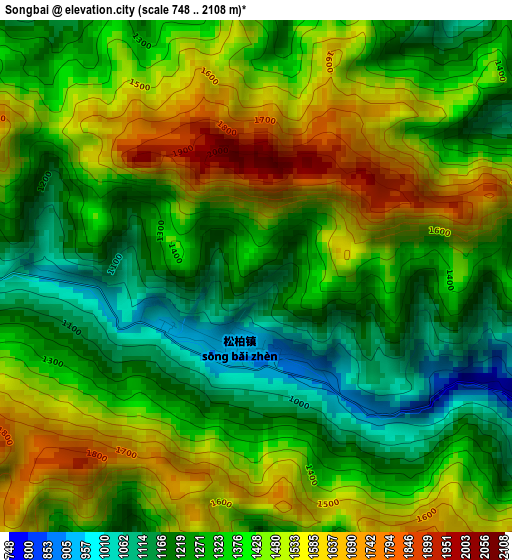
Below is the Elevation map of Songbai, which displays elevation range with different colors. Scale of the first map is from 748 to 2108 m (2454 to 6916 ft) with average elevation of 1378.4 meters (=4522 ft) [note 1]
These maps also provides idea of topography and contour of this city, they are displayed at different zoom levels. More info about maps, scale and edge coordinates you can find below images.
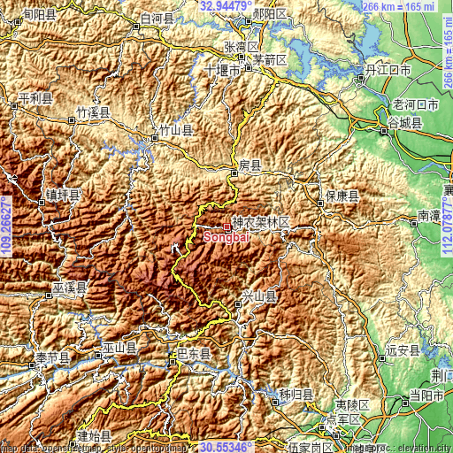
| \ | Map #1 | Topo.Map |
| Scale [m] | 748..2108 m | × |
| Scale [ft] | 2454..6916 ft | × |
| Average | 1378.4 m = 4522 ft | × |
| Width | 8.31 km = 5.2 mi | 265.9 km = 165.2 mi |
| Height | 8.31 km = 5.2 mi | 265.9 km = 165.2 mi |
| ↑Max Latitude | 31.794209° | 32.94479° |
| Latitude at center | 31.75685° | 31.75685° |
| ↓Min Latitude | 31.719476° | 30.55346° |
| ← Min Longitude | 110.628575° | 109.26627° |
| Longitude center | 110.67252° | 110.67252° |
| →Max Longitude | 110.716465° | 112.07877° |
Nearby cities:
Cities around Songbai sort by population:
• Shiyan elevation 247 m
99.5 km,  5°
5°
• Nanzhang Chengguanzhen 130 m
109.2 km,  88°
88°
• Gucheng Chengguanzhen 88 m
106.9 km,  58°
58°
• Zhuxi Chengguanzhen 450 m
109.6 km,  305°
305°
• Chengxiang 215 m
107.1 km,  248°
248°
• Maoping 229 m
107.1 km,  164°
164°
• Wushan 351 m
106.7 km,  225°
225°
• Xinling 597 m
88 km,  202°
202°
• Zhushan Chengguanzhen 259 m
66.1 km,  321°
321°
• Baokang Chengguanzhen 306 m
56.8 km,  76°
76°
• Gufu 918 m
44.2 km,  173°
173°
• Fangxian Chengguanzhen 432 m
33.7 km, 9°
Multilingual:
 En español:
Songbai elevación 1166 m.
 En France:
Songbai élévation 1166 m.
 Auf Deutsch:
Songbai höhe über dem Meeresspiegel ist 1166 m.

Sources and notes:
- [note 1] Map square and city borders are not equal. Map elevation data is calculated only from area inside that square.
- [src 1] Elevation data from geonames database provided with same terms of usage.
- [src 2] The elevation map of Songbai is generated using elevation data from NASA's 3 arcsec (90m) resolution SRTM data.
- [src 3] Base (background) map © OpenStreetMap contributors tiles are generated by Geofabrik and OpenTopoMap.
Copyright & License:
This Songbai Elevation Map is licensed under CC BY-SA. You may reuse any part from this page, if you give a proper credit by linking to this URL:
 More info on terms of use page.