Enshi elevation
Enshi (Hubei, Enshi Tujiazu Miaozu Zizhizhou), China elevation is 451 meters and Enshi elevation in feet is 1480 ft above sea level [src 1]. Enshi is a seat of a second-order administrative division (feature code) with elevation that is 107 meters (351 ft) smaller than average city elevation in China.
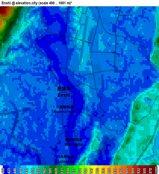
Below is the Elevation map of Enshi, which displays elevation range with different colors. Scale of the first map is from 400 to 1001 m (1312 to 3284 ft) with average elevation of 463 meters (=1519 ft) [note 1]
These maps also provides idea of topography and contour of this city, they are displayed at different zoom levels. More info about maps, scale and edge coordinates you can find below images.
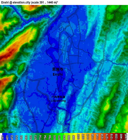
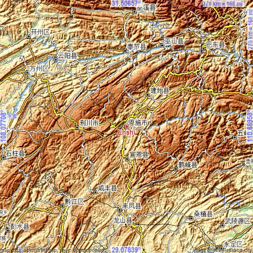
| \ | Map #1 | Map #2 | Topo.Map |
| Scale [m] | 400..1001 m | 391..1440 m | × |
| Scale [ft] | 1312..3284 ft | 1283..4724 ft | × |
| Average | 463 m = 1519 ft | 592.4 m = 1944 ft | × |
| Width | 8.44 km = 5.2 mi | 16.88 km = 10.5 mi | 270 km = 167.8 mi |
| Height | 8.44 km = 5.2 mi | 16.88 km = 10.5 mi | 270 km = 167.8 mi |
| ↑Max Latitude | 30.337935° | 30.375855° | 31.50657° |
| Latitude at center | 30.3° | 30.3° | 30.3° |
| ↓Min Latitude | 30.26205° | 30.224086° | 29.07839° |
| ← Min Longitude | 109.439385° | 109.395439° | 108.07708° |
| Longitude center | 109.48333° | 109.48333° | 109.48333° |
| →Max Longitude | 109.527275° | 109.571221° | 110.88958° |
Nearby cities:
Cities around Enshi sort by population:
• Lichuan elevation 1255 m
60.8 km,  270°
270°
• Qianjiang 582 m
109.3 km,  218°
218°
• Shuangjiang 224 m
104.8 km,  312°
312°
• Wushan 351 m
94.5 km,  23°
23°
• Min’an 480 m
93.6 km,  182°
182°
• Xiangfeng 461 m
88.4 km,  185°
185°
• Yong’an 345 m
80.2 km,  358°
358°
• Gaoleshan 739 m
76.4 km,  205°
205°
• Rongmei 503 m
69.1 km,  130°
130°
• Yezhou 557 m
40.9 km,  34°
34°
• Zhushan 507 m
34 km, 180°
• Xiaoduchuan 427 m
1.2 km, 214°
Multilingual:
 En español:
Enshi elevación 451 m.
 En France:
Enshi élévation 451 m.


Sources and notes:
- [note 1] Map square and city borders are not equal. Map elevation data is calculated only from area inside that square.
- [src 1] Elevation data from geonames database provided with same terms of usage.
- [src 2] The elevation map of Enshi is generated using elevation data from NASA's 3 arcsec (90m) resolution SRTM data.
- [src 3] Base (background) map © OpenStreetMap contributors tiles are generated by Geofabrik and OpenTopoMap.
Copyright & License:
This Enshi Elevation Map is licensed under CC BY-SA. You may reuse any part from this page, if you give a proper credit by linking to this URL:
 More info on terms of use page.