Min’an elevation
Min’an (Hunan), China elevation is 480 meters and Min’an elevation in feet is 1575 ft above sea level [src 1]. Min’an is a seat of a third-order administrative division (feature code) with elevation that is 78 meters (256 ft) smaller than average city elevation in China.
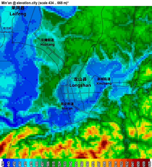
Below is the Elevation map of Min’an, which displays elevation range with different colors. Scale of the first map is from 434 to 668 m (1424 to 2192 ft) with average elevation of 502.3 meters (=1648 ft) [note 1]
These maps also provides idea of topography and contour of this city, they are displayed at different zoom levels. More info about maps, scale and edge coordinates you can find below images.
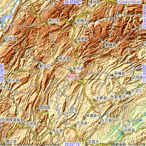
| \ | Map #1 | Topo.Map |
| Scale [m] | 434..668 m | × |
| Scale [ft] | 1424..2192 ft | × |
| Average | 502.3 m = 1648 ft | × |
| Width | 8.51 km = 5.3 mi | 272.3 km = 169.2 mi |
| Height | 8.51 km = 5.3 mi | 272.3 km = 169.2 mi |
| ↑Max Latitude | 29.497756° | 30.67647° |
| Latitude at center | 29.4595° | 29.4595° |
| ↓Min Latitude | 29.421229° | 28.22775° |
| ← Min Longitude | 109.393055° | 108.03075° |
| Longitude center | 109.437° | 109.437° |
| →Max Longitude | 109.480945° | 110.84325° |
Nearby cities:
Cities around Min’an sort by population:
• Enshi elevation 451 m
93.6 km,  2°
2°
• Huayuan 302 m
97 km,  177°
177°
• Zhongduo 672 m
94.4 km,  223°
223°
• Xiaoduchuan 427 m
92.5 km, 2°
• Qianling 236 m
85.6 km,  166°
166°
• Rongmei 503 m
74.6 km,  49°
49°
• Liyuan 325 m
70 km,  95°
95°
• Qianjiang 582 m
64.6 km,  277°
277°
• Lingxi 251 m
64.2 km,  141°
141°
• Zhushan 507 m
59.6 km, 3°
• Gaoleshan 739 m
37.3 km,  310°
310°
• Xiangfeng 461 m
6.3 km,  328°
328°
Multilingual:
 En español:
Min’an elevación 480 m.
 En France:
Min’an élévation 480 m.


Sources and notes:
- [note 1] Map square and city borders are not equal. Map elevation data is calculated only from area inside that square.
- [src 1] Elevation data from geonames database provided with same terms of usage.
- [src 2] The elevation map of Min’an is generated using elevation data from NASA's 3 arcsec (90m) resolution SRTM data.
- [src 3] Base (background) map © OpenStreetMap contributors tiles are generated by Geofabrik and OpenTopoMap.
Copyright & License:
This Min’an Elevation Map is licensed under CC BY-SA. You may reuse any part from this page, if you give a proper credit by linking to this URL:
 More info on terms of use page.