Lingxi elevation
Lingxi (Hunan), China elevation is 251 meters and Lingxi elevation in feet is 823 ft above sea level [src 1]. Lingxi is a seat of a third-order administrative division (feature code) with elevation that is 307 meters (1007 ft) smaller than average city elevation in China.
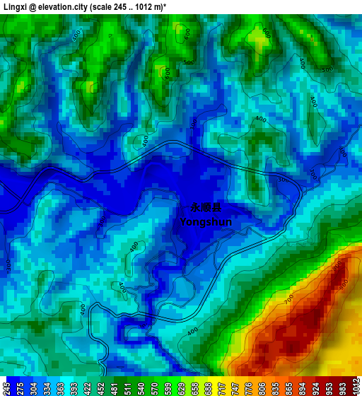
Below is the Elevation map of Lingxi, which displays elevation range with different colors. Scale of the first map is from 245 to 1012 m (804 to 3320 ft) with average elevation of 426.1 meters (=1398 ft) [note 1]
These maps also provides idea of topography and contour of this city, they are displayed at different zoom levels. More info about maps, scale and edge coordinates you can find below images.
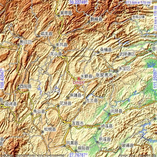
| \ | Map #1 | Topo.Map |
| Scale [m] | 245..1012 m | × |
| Scale [ft] | 804..3320 ft | × |
| Average | 426.1 m = 1398 ft | × |
| Width | 8.55 km = 5.3 mi | 273.5 km = 169.9 mi |
| Height | 8.55 km = 5.3 mi | 273.5 km = 169.9 mi |
| ↑Max Latitude | 29.043426° | 30.22749° |
| Latitude at center | 29.005° | 29.005° |
| ↓Min Latitude | 28.966559° | 27.76787° |
| ← Min Longitude | 109.800775° | 108.43847° |
| Longitude center | 109.84472° | 109.84472° |
| →Max Longitude | 109.888665° | 111.25097° |
Nearby cities:
Cities around Lingxi sort by population:
• Qianzhou elevation 201 m
77 km,  188°
188°
• Zhangjiajie 174 m
63.1 km,  77°
77°
• Wulingyuan 327 m
77.9 km,  60°
60°
• Dehang 245 m
77.7 km,  183°
183°
• Baisha 107 m
94.6 km,  157°
157°
• Yuanling 120 m
82.4 km,  138°
138°
• Xiangfeng 461 m
70.4 km,  322°
322°
• Min’an 480 m
64.2 km, 321°
• Huayuan 302 m
58.7 km,  217°
217°
• Liyuan 325 m
52.9 km,  34°
34°
• Guyang 364 m
44.3 km,  168°
168°
• Qianling 236 m
37.9 km,  210°
210°
Multilingual:
 En español:
Lingxi elevación 251 m.
 En France:
Lingxi élévation 251 m.


Sources and notes:
- [note 1] Map square and city borders are not equal. Map elevation data is calculated only from area inside that square.
- [src 1] Elevation data from geonames database provided with same terms of usage.
- [src 2] The elevation map of Lingxi is generated using elevation data from NASA's 3 arcsec (90m) resolution SRTM data.
- [src 3] Base (background) map © OpenStreetMap contributors tiles are generated by Geofabrik and OpenTopoMap.
Copyright & License:
This Lingxi Elevation Map is licensed under CC BY-SA. You may reuse any part from this page, if you give a proper credit by linking to this URL:
 More info on terms of use page.